Garmin G1000 Pilot’s Guide for the Diamond DA42NG
190-00-00962-04 Rev. A
386
HAZARD AVOIDANCE
SYSTEM
OVERVIEW
FLIGHT
INSTRUMENTS
EIS
AUDIO PANEL
& CNS
FLIGHT
MANAGEMENT
HAZARD
AVOIDANCE
AFCS
ADDITIONAL
FEATURES
APPENDICESINDEX
at 50 nm, 20,000 feet. In other words, at this tilt setting, a ground return (such as a mountain peak) being
displayed at 10 nm would have a maximum distance below the aircraft of 4,000 feet. A ground target return
being displayed at five nm would have a maximum distance below the aircraft of 2,000 feet.
This setup provides a good starting point for practical use of the airborne weather radar. There are many
other factors to consider in order to become proficient at using weather radar in all situations.
ALTITUDE COMPENSATED TILT (ACT) (GWX 70 ONLY)
The Altitude Compensated Tilt feature of the GWX 70 enables the system to automatically adjust the
antenna beam tilt angle setting based on aircraft altitude changes. For example, if the ACT feature is enabled
and the aircraft climbs, the system compensates by adjusting the tilt downward. As the aircraft descends
with ACT enabled, the system adjusts the antenna tilt upward. The system uses the ground as a reference for
adjusting the antenna tilt setting with ACT enabled.
WEATHER MAPPING AND INTERPRETATION
WEATHER DISPLAY INTERPRETATION
When evaluating various target returns on the weather radar display, the colors denote precipitation
intensity and rates shown in the following table.
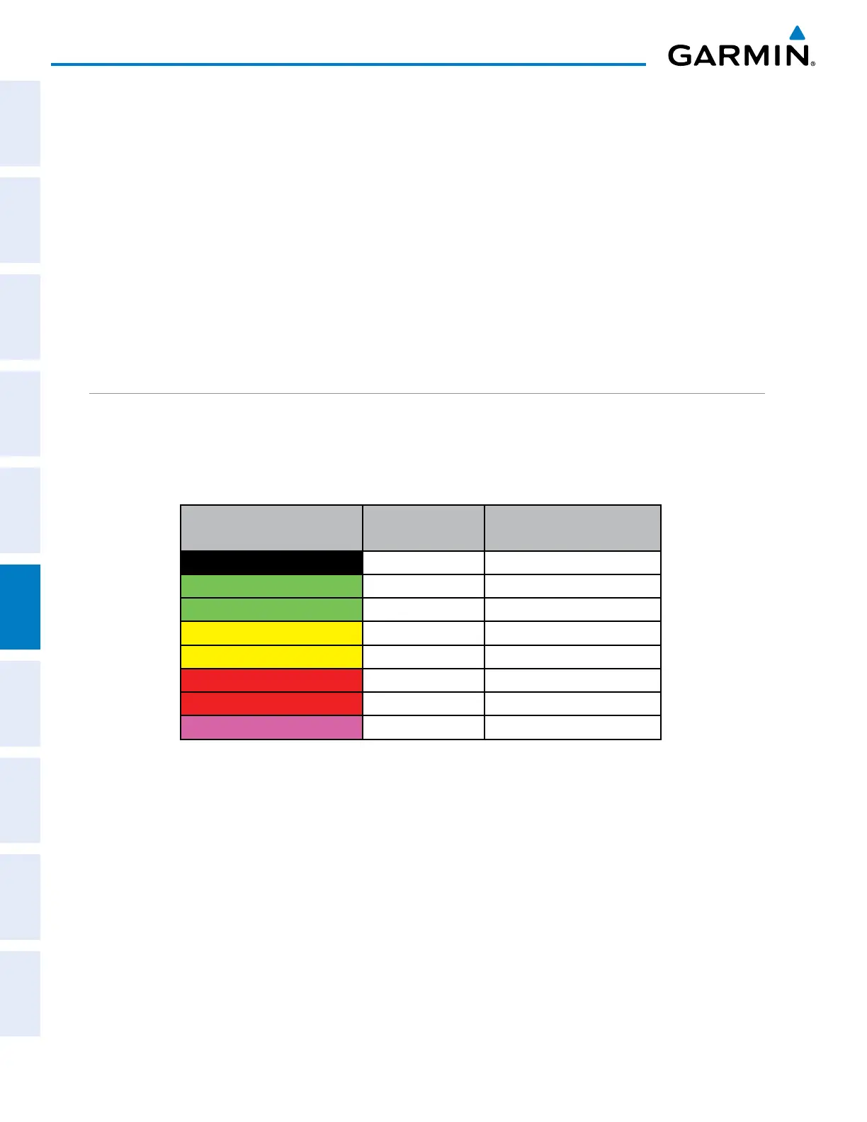
Weather Mode Color Intensity
Approximate
Precipitation Rate (in/hr.)
Black < 23 dBZ < .01.
Green (GWX 68) 23 dBZ to < 32 dBZ .01 - 0.1.
Green (GWX 70) 23 dBZ to < 33 dBZ .01 - 0.1.
Yellow (GWX 68) 32 dBZ to < 41 dBZ 0.1 - 0.5
Yellow (GWX 70) 33 dBZ to < 41 dBZ 0.1 - 0.5
Red (GWX 68) 41 dBZ to < 50 dBZ 0.5 - 2
Red (GWX 70) 41 dBz and greater 0.5 and greater
Magenta* (GWX 68 only) 50 dBZ and greater > 2
*Magenta color not applicable to GWX 70 installations
Table 6-15 Precipitation Intensity Levels
thunDeRstoRms
Updrafts and downdrafts in thunderstorms carry water through the cloud. The more severe the drafts, the
greater the number and size of the precipitation droplets. With this in mind, the following interpretations
can be made from what is displayed on the weather radar. Avoid these areas by an extra wide margin.
• In areas where the displayed target intensity is red or magenta (indicating large amounts of precipitation),
the turbulence is considered severe. Magenta is only shown in GWX 68 installations.
• Areas that show steep color gradients (intense color changes) over thin bands or short distances suggest
irregular rainfall rate and strong turbulence.

 Loading...


