190-00962-04 Rev. A
Garmin G1000 Pilot’s Guide for the Diamond DA42NG
445
HAZARD AVOIDANCE
SYSTEM
OVERVIEW
FLIGHT
INSTRUMENTS
EIS
AUDIO PANEL
& CNS
FLIGHT
MANAGEMENT
HAZARD
AVOIDANCE
AFCS
ADDITIONAL
FEATURES
APPENDICES INDEX
TRAFFIC DESCRIPTION
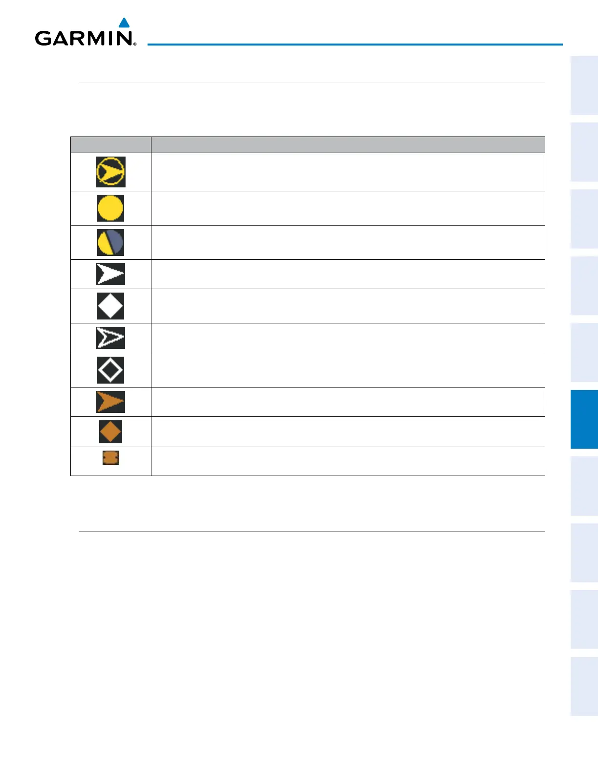
The symbols used to display ADS-B traffic are shown in Table 6-39. Above or below the traffic symbol is the
traffic identifier, and altitude. A small up or down arrow next to the traffic symbol indicates that the traffic is
climbing or descending at a rate of at least 500 feet per minute.
Symbol Description
Traffic Advisory with directional information. Points in the direction of the intruder aircraft track.
Traffic Advisory without directional information.
Traffic Advisory out of the selected display range. Displayed at outer range ring at proper bearing.
Proximity Advisory with directional information. Points in the direction of the aircraft track.
Proximity Advisory without directional information.
Non-threat traffic with directional information. Points in the direction of the intruder aircraft track.
Non-threat traffic without directional information.
Traffic located on the ground with directional information. Points in the direction of the aircraft track. Ground traffic is only
displayed when ADS-B is in Surface (SURF) Mode or own aircraft is on the ground.
Ground traffic without directional information. Ground traffic is only displayed when ADS-B is in Surface (SURF) Mode or own
aircraft is on the ground.
Non-aircraft ground traffic. Ground traffic is only displayed when ADS-B is in Surface (SURF) Mode or own aircraft is on the
ground.
Table 6-39 ADS-B Traffic Symbology
OPERATION
TRAFFIC MAP PAGE
The Traffic Map Page shows surrounding traffic data in relation to the aircraft’s current position and altitude,
without basemap clutter. Aircraft orientation is always heading up unless there is no valid heading. Map
range is adjustable with the Joystick, as indicated by the map range rings.
The traffic mode and altitude display mode are annunciated in the upper left corner of the page.

 Loading...


