Do you have a question about the SkyTraxx 2.1 and is the answer not in the manual?
Select between Fly and Hike operating modes. Each mode offers different screen pages and logbook features.
Configure automatic or manual recording start/stop. Recording can be locked to prevent accidental logging.
View and manage FANET friends and users. Includes status, distance, and SOS call functionality.
Display real-time wind data received via FANET from ground stations. Shows direction and speed.
Access and review recorded flight data. Includes options for analysis, playback, and data export.
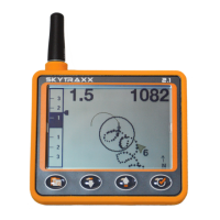
View basic flight data displayed over several pages.
Display the track with altitude profile. Navigate through the flight using buttons.
Replay selected flights on the display with adjustable playback speed.
Display a path that can be followed as a navigation aid.
Upload IGC files to an online contest server via WiFi.
Convert flight data to KML format for viewing in Google Earth.
Permanently erase a flight record. This action cannot be undone.
Tools for flight path planning and guidance. Includes waypoint management, routes, and competition tasks.
Navigate to existing waypoints. The device displays the direction to the selected waypoint.
Define an ordered list of waypoints leading to a destination. Activate to start navigation.
Utilize extensive competition functions based on FAI guidelines. Manage competition folders, tasks, and waypoints.
Simulate flying over the map to display airspaces and other map features. Controls adjust zoom and direction.
Create, save, edit, or delete personal waypoints for navigation and flight planning.
Configure various device parameters to personalize operation and optimize performance.
Configure variometer settings like climb/sink thresholds, silent on ground, sensitivity, integration time, and tone profile.
Adjust the device volume in 10 steps. Volume 0 switches the sound off.
Customize and add new flight screen pages. Select from various pre-defined screen layouts.
Enter pilot name for IGC file. Allows creating multiple profiles for different aircraft or flying conditions.
Configure FANET+ settings, including enabling the wireless interface, FLARM, broadcast name, and online tracking.
Upload flights to servers like DHV Leonardo or XContest via WiFi. Set up user credentials and server details.
Configure NMEA data forwarding to a mobile phone hotspot for use with apps like XCTrack.
Set the device timezone. Summer and winter time adjustments are handled automatically.
Select the device language. Currently supports German, English, and French.
Set preferred units for altitude, distance, climb rate, speed, and coordinates.
Configure and manage airspace warnings. Set horizontal/vertical distances and altitude limits for notifications.
Adjust the display contrast for better readability under various lighting conditions.
| Display Type | LCD |
|---|---|
| GPS | Yes |
| Resolution | 320 x 240 pixels |
| Brightness | Adjustable |
| Viewing Angle | Wide |
| Battery | Rechargeable Li-ion |
| Operating Temperature | -10°C to +50°C |
| Power Supply | USB |
| Interface | USB |
| Connectivity | Bluetooth |