P4 Multispectral User Manual
14
©
2019 DJI All Rights Reserved.
Failsafe RTH
The Forward Vision System allows the aircraft to create a real-time map of its ight route as it ies.
If the Home Point was successfully recorded and the compass is functioning normally, Failsafe
RTH will be automatically activated if the remote controller signal is lost for more than three
seconds. The aircraft will plan its return route and retrace its original ight route home. During
RTH, if the remote controller signal is recovered, users can control the aircraft altitude and speed.
Press the RTH button once to cancel RTH.
Smart RTH
Use the RTH button on the remote controller when GNSS is available to initiate Smart RTH. The
aircraft will then automatically return to the last recorded Home Point. Use the remote controller
to control the aircraft’s speed or altitude to avoid a collision during the Smart RTH process. As
the aircraft returns, it will use the primary camera to identify obstacles as far as 300m in front,
allowing it to plan a safe route home. Press and hold the Smart RTH button once to start the
process, and press the Smart RTH button again to terminate the procedure and regain full
control of the aircraft.
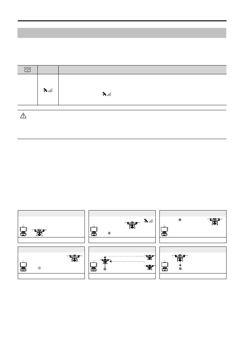
Failsafe Illustration
5
RTH (adjustable altitude)
Fast Blinking Yellow
Height over HP<=Failsafe Altitude
1 Record Home Point
Blinking Green
3 Remote Controller Signal Lost
Fast Blinking Yellow
2 Conrming Home Point
Blinking Green
6 Landing (after hovering for 5 secs)
Fast Blinking Yellow
4
Signal Lost Lasts (after 3 sec.)
Fast Blinking Yellow
Height over HP>Failsafe Altitude
Elevate to Failsafe Altitude
Failsafe Altitude
×
>3S
× ×
×
Return to Home (RTH)
Return to Home (RTH) function brings the aircraft back to the last recorded Home Point. There
are three types of RTH: Smart RTH, Low Battery RTH, and Failsafe RTH. This section describes
these three scenarios in detail.
GNSS
Description
Home
Point
If a strong GNSS signal was acquired before takeoff, the Home Point is the
location from which the aircraft launched. The GNSS signal strength is indicated
by the GNSS icon ( Less than 4 bars is considered a weak GNSS signal).
The aircraft status indicators will blink rapidly when the home point is recorded.
The aircraft can sense and avoid obstacles when the Forward Vision System is enabled and lighting
conditions are sucient. The aircraft will automatically climb up to avoid obstacles and descend slowly
as it returns to the Home Point. To ensure the aircraft returns home forwards, it cannot rotate or y left
and right during RTH while the Forward Vision System is enabled.