Leaders in Pipeline Survey Systems
OPERATOR’S MANUAL
Issue 4.04 - 1207 24
4.2. Demo Mode
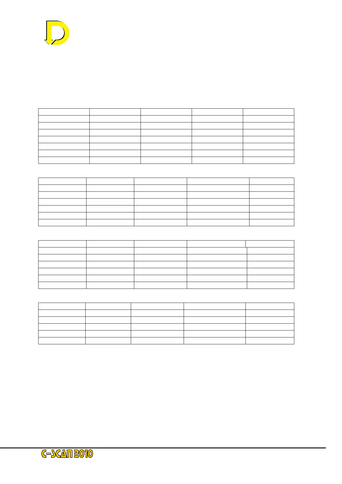
Demo Mode enables all functions within the C-Scan model 2010 to be simulated. Four
‘standard’ surveys have been stored in the unit’s memory. The tables below show the data for
these surveys:
Survey 1
Current Depth Latitude Longitude Distance
163.4 1.29 44N29.534' 012W02.850' 0
156.6 1.24 44N29.485' 012W03.050' 65
88.52 1.31 44N29.467' 012W03.150' 22
85.91 1.23 44N29.44' 012W03.300' 70
85.38 1.04 44N29.43' 012W03.384' 25
55.91 1.24 44N29.424' 012W03.539' 20
52.64 1.11 44N29.424' 012W03.700'' 58
Survey 2
Current Depth Latitude Longitude Distance
415.5 1.91 44N29.534' 012W02.850' 0
21.44 1.6 44N29.485' 012W03.050' 320
13.64 1.77 44N29.467' 012W03.150' 150
10.44 1.57 44N29.440' 012W03.300' 200
9.97 1.96 44N29.430' 012W03.384' 130
5.79 1.71 44N29.424' 012W03.539' 200
Survey 3
Current Depth Latitude Longitude Distance
30.00 .91 44N29.534' 012W02.850' 0
21.44 1.6 44N29.485' 012W03.050' 320
13.64 1.77 44N29.467' 012W03.150' 150
10.44 1.57 44N29.44' 012W03.300' 200
9.97 1.96 44N29.43' 012W03.384' 130
5.79 1.71 44N29.424' 012W03.539' 200
Survey 4
Current Depth Latitude Longitude Distance
400 .98 Choose
380 1.2 Choose
360 3.0 Choose
300 3.5 Choose
290 3.01 Choose
Each survey has different characteristics. Survey 1 to Survey 3 has GPS co-ordinates;
Survey 4 does not have GPS co-ordinates and requires manual entry.
 Loading...

