EasyManuals Logo

Garmin GPSMAP 1243xsv User Manual

Garmin GPSMAP 1243xsv
208 pages
To Next Page IconTo Next Page
To Previous Page IconTo Previous Page
Page #163 background imageLoading...
Page #163 background image
Surface Winds
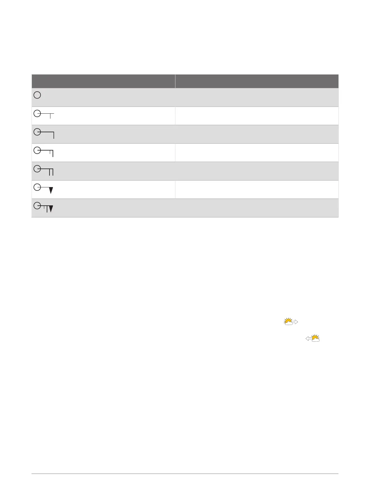
Surface wind vectors appear on the Sea Conditions chart using wind barbs that indicate the direction from
which the wind is blowing. A wind barb is a circle with a tail. The line or flag attached to the tail of the wind
barb indicates the wind speed. A short line represents 5 knots, a long line represents 10 knots, and triangle
represents 50 knots.
Wind Barb Wind Speed
Calm
5 knots
10 knots
15 knots
20 knots
50 knots
65 knots
Wave Height, Wave Period, and Wave Direction
Wave heights for an area appear as variations in color. Different colors indicate different wave heights, as
shown in the legend.
The wave period indicates the time (in seconds) between successive waves. Wave period lines indicate areas
that have the same wave period.
Wave directions appear on the chart using red arrows. The direction of each arrow pointer indicates the
direction in which a wave is moving.
Viewing Forecast Sea Conditions Information for Another Time Period
1 Select Charts > Sea Conditions.
2 Select an option:
To view forecasted sea conditions for the next 36 hours, in 12-hour increments, select multiple
times.
To view the forecasted sea conditions for the previous 36 hours, in 12-hour increments, select
multiple times.
Viewing Sea Temperature Information
The Sea Temperature weather chart shows the present water temperature and present surface pressure
conditions.
Select Charts > Sea Temperature.
SiriusXM Weather 151

Table of Contents

Questions and Answers:

Question and Answer IconNeed help?

Do you have a question about the Garmin GPSMAP 1243xsv and is the answer not in the manual?

Garmin GPSMAP 1243xsv Specifications

General IconGeneral
Display Resolution1280 x 800 pixels
Display TypeWXGA display
TouchscreenYes
KeypadYes
Water RatingIPX7
AntennaInternal or external over NMEA 2000
Receiver10 Hz
Garmin Marine Network Ports2
NMEA 2000 Ports1
NMEA 0183 Input Ports1
NMEA 0183 Output Ports1
Wireless ConnectivityYes
J1939 ConnectivityYes
BlueChart g3 ChartsYes
LakeVü g3 ChartsYes
Waypoints5, 000
Routes100
Track Log50, 000 points; 50 saved tracks
Sonar CapabilitiesYes
CHIRP SonarYes
ClearVüYes
SideVüYes
Traditional Sonar Frequency50/77/83/200 kHz
ClearVü/SideVü Frequency260/455/800 kHz
Weight5.1 lbs (2.3 kg)
Mounting OptionsFlush
Video Input Ports1 BNC
Accepts Data CardsmicroSD card
CHIRP FrequencyLow, High
Transmit Power500 W (RMS)
Operating Temperature-15°C to 55°C (5°F to 131°F)
Storage Temperature-4°F to 158°F (-20° to 70°C)
Power Input10-32 Vdc

Related product manuals