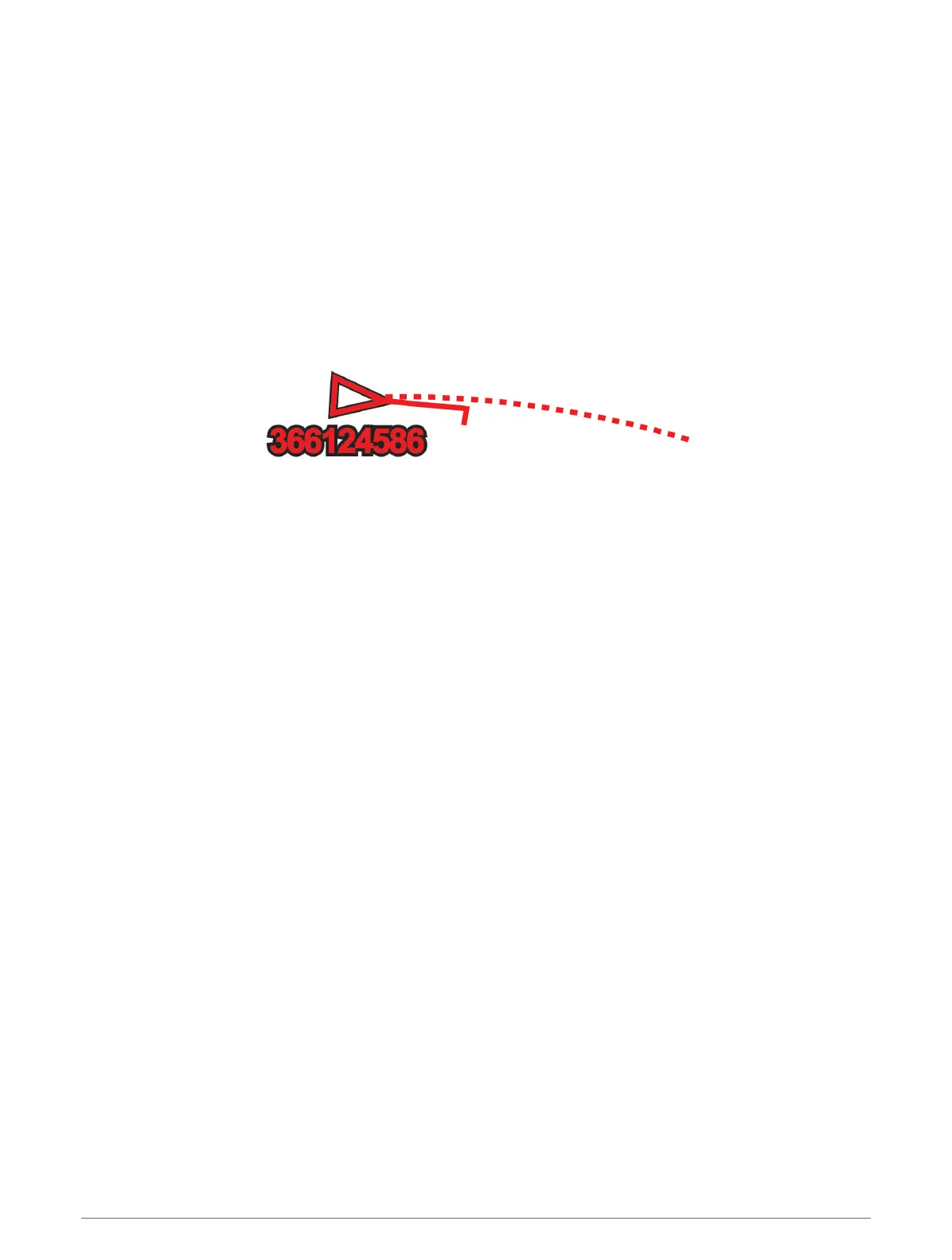
Heading and Projected Course of Activated AIS Targets
When heading and course over ground information are provided by an activated AIS target, the heading of the
target appears on a chart as a solid line attached to the AIS target symbol. A heading line does not appear on a
3D chart view.
The projected course of an activated AIS target appears as a dashed line on a chart or a 3D chart view. The
length of the projected course line is based on the value of the projected heading setting. If an activated AIS
target is not transmitting speed information, or if the vessel is not moving, a projected course line does not
appear. Changes in the speed, course over ground, or rate of turn information transmitted by the vessel can
impact the calculation of the projected course line.
When course over ground, heading, and rate of turn information are provided by an activated AIS target, the
projected course of the target is calculated based on the course over ground and the rate of turn information.
The direction in which the target is turning, which is also based on the rate of turn information, is indicated by
the direction of the barb at the end of the heading line. The length of the barb does not change.
When course over ground and heading information are provided by an activated AIS target, but rate of turn
information is not provided, the projected course of the target is calculated based on the course over ground
information.
Activating a Target for an AIS Vessel
1 From a chart or 3D chart view, select Options > Layers > Other Vessels > AIS > AIS List .
2 Select a vessel from the list.
3 Select Review and review the target information.
4 Select Activate Target.
Viewing Information about a Targeted AIS Vessel
You can view the AIS signal status, MMSI, GPS speed, GPS heading, and other information that is reported about
a targeted AIS vessel.
1 From a chart or a 3D chart view, select an AIS vessel.
2 Select AIS Vessel.
Deactivating a Target for an AIS Vessel
1 From a chart or a 3D chart view, select an AIS vessel.
2 Select AIS Vessel > Deactivate.
Viewing a List of AIS and MARPA Threats
From any Radar screen or the Radar overlay, you can view and customize the appearance of a list of AIS and
MARPA threats.
1 From a Radar screen, select Options > Layers > Other Vessels.
2 Select an option:
• To view a list of AIS threats, select AIS > AIS List.
• To view a list of MARPA threats, select MARPA > MARPA List.
3 If necessary, select Display Options > Show, and select the type of threats to include in the list.
Charts and 3D Chart Views 33
 Loading...