iii
INTRODUCTION
Capabilities
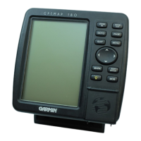
Designed for detailed electronic charting and simple operation, the GARMIN
GPSMAP 180 is a powerful navigation device that can help guide you in water-
ways around the world:
Precision Performance
160 x 240 pixel High-contrast 4-level gray LCD screen
PhaseTrac12
TM
receiver tracks and uses up to 12 satellites simultaneously
for fast, accurate positioning
Differential-Ready just add the optional GBR 21 beacon receiver for better
than 10-meter accuracy
Gasketed case for use in exposed locations
Advanced Navigating and Plotting
250 alphanumeric waypoints with selectable icons and comments
Built-in worldwide database usable from 4096 to 64 nm scales
20 reversible routes with up to 30 waypoints each
Micro G-chart
TM
electronic charting with inland and offshore coverage
On-screen point-to-point distance and bearing calculations
TracBack
TM
route feature which allows you to quickly retrace your track log to
a starting position
Built-in simulator mode