Do you have a question about the Hi-Target ZTS-320 Series and is the answer not in the manual?
Provides feedback on instrument version, number, and purchase date.
Instrument measures after switch-on; azimuth info retained on battery reset.
Easy management of file system, including data increase, deletion, and transmission.
Measures various surfaces without prism; ideal for inaccessible targets.
Includes REM, Offset, MLM, Resection, Area calculation, Roadway design.
Convenient for using diagonal eyepiece, aiding high-rise building observation.
Aids in directing the station point and free stationing.
Warnings and precautions for safe laser operation, preventing eye damage and improper use.
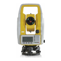
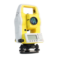
Identifies and labels key parts of the total station instrument.
Explains the function of each symbol and key on the instrument's keyboard.
Defines symbols and their meanings displayed on the instrument's screen.
Details the reference functions of common soft keys used in the instrument.
Describes the functionality and pages within the Angle Mode.
Explains the two menu pages and functions within the Distance Mode.
Details the three menu pages and functions for Coordinate Mode.
Explains the process and options for saving measured data points and coordinates.
Covers powering the instrument on/off, tilt correction, target type, prism constant, and signal.
Details atmospheric correction, refraction/curvature, and minimum angle reading setup.
Explains automatic shutdown, constants, and data file selection.
Instructions for safely unpacking and storing the total station instrument.
Covers general steps for setting up the instrument on a tripod.
Guidance on loading/unloading batteries and using prisms/pedestals.
Explains how to enter letters, numbers, and point data.
Describes how to set a desired horizontal angle manually.
Explains Hold, L/R switching, and Vertical Angle modes.
Details how to select between single, repeated, continuous, and tracking modes.
Covers saving measurements, EDM, mode selection, and BBS setup.
Procedure for measuring points when prism placement is difficult, using angles.
Explains single and double distance offset measurement techniques.
Covers measuring points in a plane and offset measurements for columns.
Covers menu options for surveying, station setup, BBS, and staking out.
Details file operations: dialogue box, import, export, format, and information.
Describes various measurement programs like REM, MLM, Polar Coord., Area, and Projection.
Covers index error, tilt calibration, constants, and date/time settings.
Explains units, EDM modes, grid factor, communication, and storage disc selection.
Details how to input horizontal and vertical alignment for roadway design.
Explains the process and parameters for staking out designed roadway points.
Procedures for calibrating tubular and circular levels for accuracy.
Covers reticule and collimation axis adjustments for telescope alignment.
Details vertical plate index compensation and vertical index error setup.
Explains centering device calibration and addictive constant adjustment.
Covers collimation/photoelectricity axis parallelism and non-prism ranging checks.
| Model | ZTS-320 Series |
|---|---|
| Accuracy | 2" |
| Field of view | 1°30' |
| Operating temperature | -20°C to +50°C |
| Weight | 5.5 kg |
| Type | Total Station |
| Angle measurement method | Absolute Encoder |
| Minimum reading | 1" |
| Accuracy (Prism) | 2mm+2ppm |
| Accuracy (Reflectorless) | 3mm+2ppm |
| Measuring time (Tracking) | 0.3s |
| Telescope magnification | 30x |
| Display | LCD |
| Data interface | USB |
| Communication | Bluetooth |
| Battery Life | 10 hours |