Do you have a question about the Hi-Target HTS-420R and is the answer not in the manual?
Describes the absolute coded dial for direct measurement and angle retention.
Highlights large-capacity EMS memory for file management tasks.
Details the capability for surveying long distances without a prism.
Lists special measurement procedures like REM, offset, and stakeout.
Mentions the changeable eyepiece and diagonal eyepiece for observation.
Notes the ease of setup and instruction with an optional laser plummet.
Advises avoiding extreme temperatures and recommends proper storage conditions.
Advises unloading and periodically charging the battery if unused for a long time.
Emphasizes careful transport and using a stable stool for instrument setup.
Specifies cleaning tools and pre-operation inspection.
Prohibits non-professional maintenance and directs laser light away from eyes.
Explains laser classification (3R/Ⅲa) and warns against staring into the beam.
Warns about the danger of reflected laser beams and the need to avoid obstruction.
Stresses following safety measures for Class 3R laser device use.
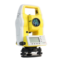
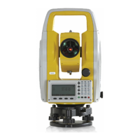
Identifies and labels the main parts of the instrument.
Describes the functions of various keys and soft keys on the instrument.
Provides instructions for unpacking and safely storing the instrument.
Details the steps for setting up the instrument, including centering and leveling.
Explains how to mount and remove the instrument's battery.
Describes battery status indicators and their meanings.
Describes the placement and usage of reflecting prisms for distance measurement.
Guides on loading and unloading the instrument's base.
Outlines the method for aiming the telescope and focusing the target.
Explains the instrument's input modes for numbers and text.
Describes how to search for points by entering their exact number.
Provides notes and precautions for distance measurements, especially without prism.
Details how to select the distance measurement mode (Single, Repeat, etc.).
Explains how to set the reflector type (Prism, Non-Prism, etc.).
Guides on setting the prism constant for accurate measurements.
Explains atmospheric refraction correction options (0.00, 0.14, 0.20).
Details atmospheric correction parameters related to pressure and temperature.
Provides formulas for altitude factor, scale factor, and grid factor.
Explains how to calculate grid distance and ground distance.
Guides on setting the horizontal angle to 0 or a desired orientation.
Provides a simple method for operating with codes.
Explains the functions of soft keys related to code management.
Details the properties of GSI codes (Name, Note, Info1-8).
Explains the soft keys for code operations (Find, New, REC, OK).
Explains the leveling function and how the compensator works.
Details the Distance Offset measurement subprogram.
Illustrates the principle of height transfer measurement.
Refers to the "Code" section for details on free coding.
Explains how to turn the laser pointer on or off.
Explains how to turn the instrument screen light on or off.
Customizes units for angles, distance, temperature, and pressure.
Configures instrument hardware settings like light, contrast, and keys.
Guides on preparations needed before starting an application.
Explains how to manage jobs for saving measurement data.
Explains how to find and select station coordinates from memory.
Guides on selecting a fix point from memory to set the station.
Details how to manually input station coordinates.
Explains how to manually input orientation (azimuth, prism height).
Describes setting orientation using known coordinates of a backsight point.
Lists Surveying as a measurement task application.
Lists Stakeout as a measurement task application.
Lists Free Station as a measurement task application.
Lists Tie Distance as a measurement task application.
Lists Area calculation as a measurement task application.
Lists Remote Height measurement as a task application.
Lists COGO calculations as a task application.
Lists Road design/stakeout as a task application.
Guides on setting the stakeout point, including extracting from job.
Describes the Polygonal method for tie distance calculation.
Groups methods for getting target points for area calculation.
Details calculation for remote height when prism height is known.
Explains calculating plane coordinates using bearing and distance.
Allows users to create and manage different road definitions.
Explains defining horizontal curves using elements or intersection methods.
Outlines the three methods for road stakeout (Polar, Orthogonal, Cartesian).
Explains how measurement data is saved in selected jobs.
Describes how to search for fixpoints by name or wildcard.
Guides on adding new fixpoints and their coordinates.
Explains how to edit existing fixpoints.
Details how to delete selected fixpoints from a job.
Guides on viewing measurement data saved in jobs.
Describes how to input and save code names and information.
Explains importing data (points, codes) from computer or UDisk.
Covers settings for light, contrast, keys, beep, tilt, and units.
Enters the adjustment menu for instrument calibration.
Displays instrument type, SN, firmware, date, and time.
Guides on setting the system date in yyyymmdd format.
Guides on setting the system time in hhmmss format.
Details the initial steps involving PIN entry and connecting to a computer.
Details checkout and calibration of the instrument's tube level.
Explains how to inspect and calibrate the instrument's additive constant.
Describes checkout and calibration for parallelism of axes.
Specifies the instrument model and angle measurement parameters.
Lists specifications for the telescope and compensator.
Lists parameters for distance measurement with reflector and without prism.
Lists odometry parameters and communication interface/format.
Specifies the operation system.
Lists display and keyboard specifications.
Lists specifications for the laser plummet.
Lists environmental operating conditions and instrument weight.
Lists battery type, voltage, capacity, and working time.
Provides an example of horizontal curve calculation input elements.
Lists input elements for intersection calculations in road design.
Explains the format of the first line of exported file records (type, name, etc.).
Details the second line of exported file records (data types, records).
| Brand | Hi-Target |
|---|---|
| Model | HTS-420R |
| Category | Measuring Instruments |
| Language | English |