49Navigation
ControlsCommunicationNavigationEntertainment
How to use the map
Applies to vehicles: with na
vigation system
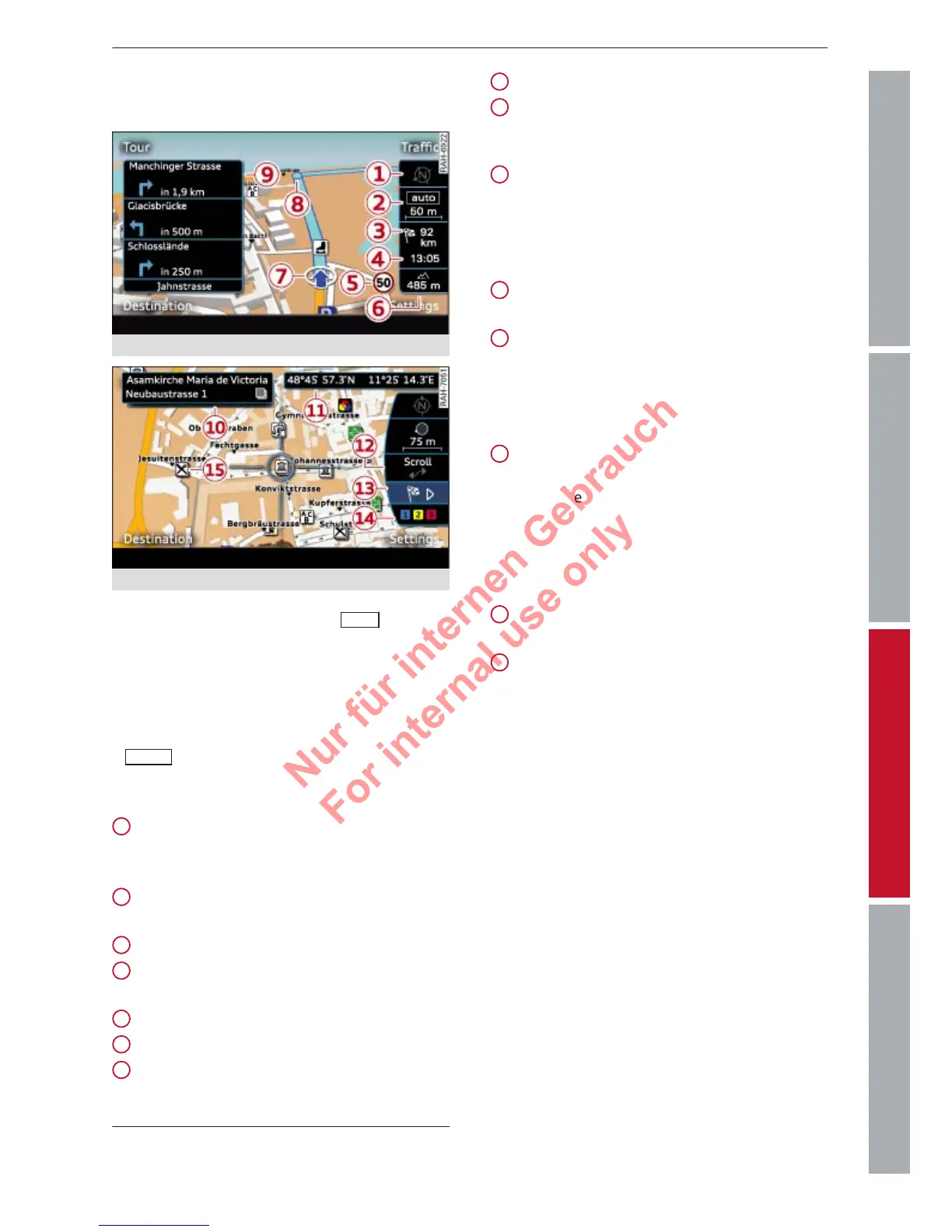
Fig. 42
Map with crosshairs switched off
Fig. 43
Map with crosshairs switched on
– T
o call up the map: Press the
NAV
button
r
epeatedly until the map appears.
– To switch on the crosshairs: Press the rotary
pushbutton while the map is being dis-
played.
– To switch off the crosshairs: Press the
BACK
button.
Crosshairs switched of
f:
Orientation: The map is displayed either
from the north position or from the driv-
ing position.
Scale: Turn the rotary pushbutton clock-
wise/anti-clockwise to zoom in or out.
Distance to destination/stopover
Calculated time of arrival at destination/
stopover
Speed display
1)
Altitude display
Location of the vehicle
1
2
3
4
5
6
7
Display of upcoming turn-off
Additional information ð page 52
Crosshairs switched on:
Additional information on the point selec
-
ted with the crosshairs: If you use the
crosshairs to select a point on the map,
any existing information on this location,
e.g. the address, will be displayed.
Display of position coordinates of the
crosshairs (longitude/latitude)
Moving along the route: This function can
be used while route guidance is activated.
Turn the rotary pushbutton clockwise/an-
ti-clockwise to move the map along the
current route.
Destination details menu: If available, de-
tails on the point selected with the cross-
hairs are displayed (e.g. address). The
point on the map selected with the cross-
hairs can be set as a destination or stop-
over, stored in the directory and called up
on the telephone.
Calculating alternative routes
ð page 53
Map contents such as traffic information,
favourite destinations or restaurants
8
9
10
11
12
13
14
15
1)
Applies to vehicles without camera-based speed limit
displa
y only.