DJI Mavic 3E/3T User Manual
75
©
2022 DJI All Rights Reserved.
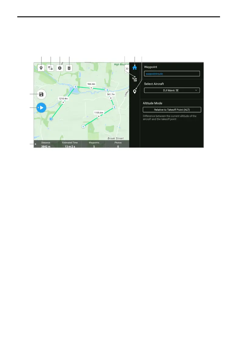
Waypoint Flights - Set Waypoints
Tap Create a Route, Waypoint, and then Set Waypoints to create a flight route. Tap on the
map to add waypoints, then configure route and waypoint settings.
1 2 3 4 6 5 7
8
9
10
1. Point of Interest (POI): tap to enable the POI feature, and a POI will be displayed on
the map. Drag to adjust its position. After a POI is added, the aircraft yaw can be set as
facing the POI, so the aircraft nose always faces the POI during the task. Tap this icon
again to disable the POI feature.
2. Reverse Flight Route: tap to reverse the flight route by swapping the start and endpoint.
S refers to the start point.
3. Clear Waypoints: tap to clear all the added waypoints.
4. Delete Selected Waypoints: tap to delete the selected waypoints.
5. Parameters List: edit the route name, advanced flight route settings, and altitude mode.
Set the aircraft type as Mavic 3E/3T.
6. Flight Route Settings: the settings are applied to the entire route, including safe takeoff
altitude, ascend to start point, aircraft speed, aircraft altitude, aircraft yaw, gimbal
control, waypoint type, and completion action. The settings will take effect on all
waypoints of the route. If users want to set parameters of an individual waypoint, please
refer to the next description.
7. Set Individual Waypoints: select a waypoint and set its parameters. Tap “<” or “>” to
switch to the previous or next waypoint. The settings include aircraft speed, aircraft
altitude, aircraft yaw mode, waypoint type, aircraft rotation direction, gimbal tilt mode,
waypoint actions, longitude, and latitude.
8. Save: tap to save the current settings and generate a flight route.
9. Perform: tap the button and then check the settings and status of the aircraft in the Pre-
flight Checklist. Tap to upload the flight route. Once the upload completes, tap the Start
button to perform the current task.
10. Flight Route Information: displays the flight length, estimated flight time, waypoint, and
photo quantity.