GNS 530(A) Pilot’s Guide and Reference
190-00181-00 Rev. G
7-16
SECTION 7
WPT PAGES
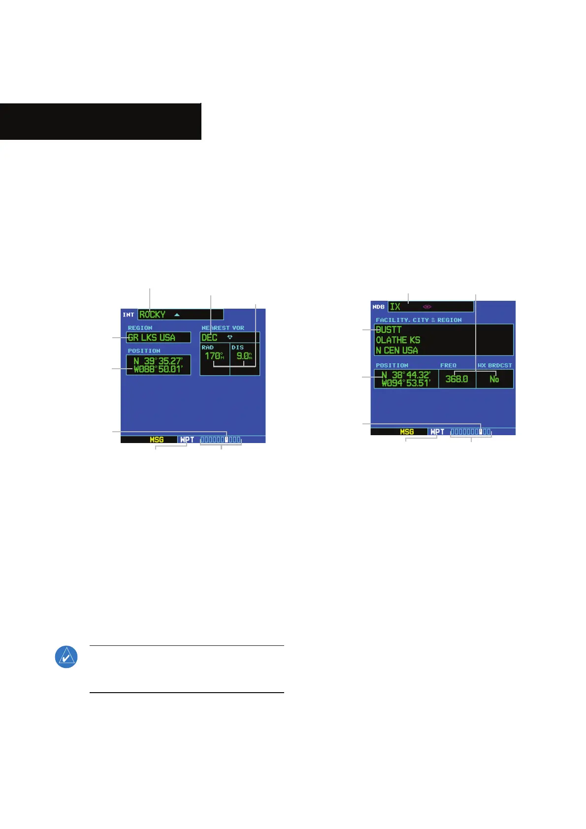
7.8 INTERSECTION PAGE
/iÊÌiÀÃiVÌÊ*>}iÊ}ÕÀiÊÇÎÓ®Ê`ë>ÞÃÊÌiÊ
latitude, longitude, region, and country for the selected
ÌiÀÃiVÌ°ÊÊ/iÊÌiÀÃiVÌÊ*>}iÊ>ÃÊ`ë>ÞÃÊÌiÊ
`iÌwiÀ]ÊÀ>`>]Ê>`Ê`ÃÌ>ViÊvÀÊÌiÊi>ÀiÃÌÊ6",]Ê
6",/]ÊÀÊ6",É°ÊÊÌiÀÃiVÌÃÊ>ÞÊÞÊLiÊ
ÃiiVÌi`ÊLÞÊ`iÌwiÀ]Ê>ÃÊ`iÃVÀLi`ÊÊ-iVÌÊÇ°£°
Figure 7-32 Intersection Page
Intersection Identifier
and Symbol
Region/
Country
Nearest
VOR and
Symbol
Radial and
Distance
from Nearest
VOR
Latitude/
Longitude
Position
Number of Pages in
Current Page Group
Position of
Current Page
within Current
Page Group
Current
Page Group
The following descriptions and abbreviations are
used:
UÊ*ÃÌÊÊ>ÌÌÕ`iÉ}ÌÕ`iÊ`i}ÀiiÃÉÕÌiÃÊÀÊ
`i}ÀiiÃÉÕÌiÃÉÃiV`î]Ê,-]ÊÀÊ1/É1*-
UÊ,ÊÊ,>`>ÊvÀÊi>ÀiÃÌÊ6",ÊÊ`i}ÀiiÃÊ
>}iÌVÊÀÊ`i}ÀiiÃÊÌÀÕiÊ`i«i`}ÊÕ«ÊÕÌÊ
Vw}ÕÀ>Ì®
UÊ-ÊÊÃÌ>ViÊvÀÊi>ÀiÃÌÊ6",]ÊÊ>ÕÌV>Ê
iÃÉÃÌ>ÌÕÌiÊiÃÉiÌiÀÃÊ`i«i`}ÊÕ«Ê
ÕÌÊVw}ÕÀ>Ì®
NOTE: The VOR displayed on the Intersection
Page is the nearest VOR, not necessarily the VOR
used to define the intersection.
7.9 NDB PAGE
The Ê*>}iÊ`ë>ÞÃÊÌiÊv>VÌÞÊ>i]ÊVÌÞ]ÊÀi}É
country, latitude, and longitude for the selected Ê
}ÕÀiÊÇÎή°ÊÊ/iÊ Ê*>}iÊ>ÃÊ`ë>ÞÃÊÌiÊfrequency
and a Üi>ÌiÀÊLÀ>`V>ÃÌÊ`V>ÌÊvÊ>««V>Li®°ÊÊÃÊ
iÌi`ÊÊ-iVÌÊÇ°£]Ê ÃÊ>ÞÊLiÊÃiiVÌi`ÊLÞÊ
`iÌwiÀ]Êv>VÌÞÊ>i]ÊÀÊV>ÌÊVÌÞ®°
Figure 7-33 NDB Page
NDB Identifier
and Symbol
Facility
Name, City,
and Region/
Country
Frequency and Weather
Broadcast Indication
Latitude/
Longitude
Position
Number of Pages in
Current Page Group
Position of
Current Page
within Current
Page Group
Current
Page Group
The following descriptions and abbreviations are
used:
UÊ-ÞLÊÊ-iiÊ-iVÌÊΰ{ÊvÀÊ>Ê}À>«VÊÕÃÌÀ>ÌÊ
of available Êsymbols
UÊ*ÃÌÊÊ>ÌÌÕ`iÉ}ÌÕ`iÊ`i}ÀiiÃÉÕÌiÃÊÀÊ
`i}ÀiiÃÉÕÌiÃÉÃiV`î]Ê,-]ÊÀÊ1/É1*-
UÊ,+ÊÊÀiµÕiVÞÊÊiÀÌâÊâ®
UÊ7ÝÊÀ`VÃÌÊÊ7i>ÌiÀÊvÀ>ÌÊÃÊLÀ>`V>ÃÌÊÊ
the selected facility’s frequency
 Loading...