GNS 530(A) Pilot’s Guide and Reference
190-00181-00 Rev. G
14-12
SECTION 14
ADDITIONAL FEATURES
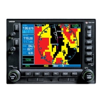
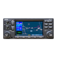
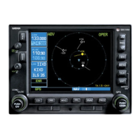
14.2 WEATHER DATA LINK INTERFACE
This section is written for:
Ê>ÀÊÊxääÊ-iÀiÃÊ>Ê-ÞÃÌiÊ-vÌÜ>ÀiÊ6iÀÃÊ
6.01 and later
Ê{Ê>Ê-vÌÜ>ÀiÊ6iÀÃÊÓ°äÎÊ>`Ê>ÌiÀ
ÊÈÉÈÊ>Ê-vÌÜ>ÀiÊ6iÀÃÊÓ°£{Ê>`Ê>ÌiÀ
Some differences in operation may be observed when
comparing the information in this manual to earlier or
later software versions.
NOTE: This section is written exclusively for 500
Series units that are configured with the GDL
49 or GDL 69(A) Data Link Satellite Receiver.
Refer to the 400/500 Series Display Interfaces
Pilot’s Guide Addendum (190-00140-10) when
interfacing with non-Garmin products.
Introduction
-ÊxÎäÊÕÌÃÊV>ÊÌiÀv>ViÊÜÌÊÌiÊÊ{ÊÀÊÌiÊ
ÊÈÉÈ°ÊÊ/iÊ -ÊxÎäÊÕÌÊ«ÀÛ`iÃÊÌiÊ`ë>ÞÊ>`Ê
VÌÀÊÌiÀv>ViÊvÀÊÌiÊÌiÝÌÕ>Ê>`Ê}À>«V>ÊÜi>ÌiÀÊ
data link.
->ÌiÌiÊÕ«i`ÊÌiÝÌÕ>Ê>`Ê}À>«V>ÊÜi>ÌiÀÊ
`>Ì>ÊÃÊÀiViÛi`ÊLÞÊÌiÊÊ{ÊÊ>ÊÀiµÕiÃÌÉÀi«ÞÊL>ÃðÊÊ
Transmissions are made using bursts of compressed
`>Ì>Ê>ÌÊ>ÊÀ>ÌiÊvÊ{nääÊL«Ã°ÊÊ7i>ÌiÀÊ`>Ì>ÊÌÀ>ÃÃÃÃÊ
>ÀiÊÃÌÀi>i`Ê`ÀiVÌÞÊÌÊÌiÊÊÈÉÈÊvÀÊÌiÊ8Ê
Satellite Radio network.
The following operational differences are noted
LiÌÜiiÊÌiÊÊÈÉÈÊ>`ÊÌiÊÊ{\
ÊÊ{ÊÊ 8,Ê>`Ê/,Ê`>Ì>ÊÃÊViVÌi`Ê
LÞÊÌiÊ >Ì>Ê7i>ÌiÀÊ-iÀÛViÊ>`Ê`ÃÃi>Ìi`Ê
ÌÊiÌiÀ}ÝÒ]Ê>ÊÜi>ÌiÀÊvÀ>ÌÊ«ÀÛ`iÀ°ÊÊ
This data is then delivered to a weather server
ÊÌiÊVÊ}ÌÊiÃÃ>}iÊ-ÞÃÌi°ÊÊ7ÌÊ
the weather data on the system, an incoming
customer request is filled, logged, and turned
>ÀÕ`ÊvÀÊ`iÛiÀÞÊÌÊ","ÊÊiÃÃÊÌ>Ê
wÛiÊÃiV`ÃÊ","ÊÃÊ>Ê«ÀÛ`iÀÊvÊ}L>Ê
iÃÃ>}}ÊÃiÀÛViÃÊÕÃ}Ê>ÊVÃÌi>ÌÊvÊÓÈÊ
Ü>ÀÌÊÀLÌ}ÊÃ>ÌiÌiî°ÊÊ/iÊiÃÃ>}iÊÃÊ
Ài>Þi`ÊvÀÊÌiÊÃ>ÌiÌiÃÊÌÊÌiÊÊ{Ê>L>À`Ê
ÌiÊ>ÀVÀ>vÌ°ÊÊ"ViÊÌiÊÊ{ÊÀiViÛiÃÊÌiÊ
message, it is displayed on the GNS 530 unit.
ÊÊÈÉÈÊÊ 8,Ê>`Ê/,Ê`>Ì>Ê
ÃÊViVÌi`ÊLÞÊÌiÊ >Ì>Ê7i>ÌiÀÊ-iÀÛViÊ
>`Ê`ÃÃi>Ìi`ÊÌÊ7Ý7ÀÃÒ]Ê>ÊÜi>ÌiÀÊ
information provider. This data is then delivered
ÌÊ8Ê->ÌiÌiÊvÀÊÀiLÀ>`V>ÃÌ°ÊÊ>Ì>ÊvÀÊÌÜÊ
8ÊÃ>ÌiÌiÃÊÃÊÌiÊ>`iÊi`>ÌiÞÊ>Û>>LiÊ
ÌÊ8ÊVÕÃÌiÀðÊÊ/iÊÊÈÉÈÊÀiViÛiÃÊ
streaming weather data, processes the data, then
sends it to the GNS 530 unit for display.
ÕVÌÃÊ«ÀÛ`i`ÊLÞÊÌiÊ7i>ÌiÀÊ>Ì>ÊÊÃÞÃÌiÊ
include:
Ê,iµÕiÃÌÊvÀÊ>`Ê`ë>ÞÊvÊ 8,ÊÀ>`>ÀÊ
imagery.
Ê,iµÕiÃÌÊvÀÊ>`Ê`ë>ÞÊvÊÌiÝÌL>Ãi`Ê/,Ê
data.
Request for and display of a compressed form of
/,Ê`>Ì>ÊÌ>ÌÊ>ÜÃÊVÊÀi«ÀiÃiÌ>ÌÃÊ>ÌÊ
reporting stations on a moving map indicating
visibility, ceiling, etc.
Ê*ÃÌÊÌÀ>V}ÊÃiÀÛViÃÊ>ÀiÊ«ÀÛ`i`ÊÌÀÕ}Ê
periodic position report transmissions from the
-ÊxÎäÊÕÌÊ>Û>>LiÊÜÌÊÊ{ÊÞ®°
 Loading...