Your device is preconfigured to use the Nokia A-GPS service,
if no service provider-specific A-GPS settings are available.
The assistance data is retrieved from the Nokia A-GPS service
server only when needed.
To disable the A-GPS service, select Menu > Applications >
GPS > GPS data and Options > Positioning settings >
Positioning methods > Assisted GPS > Disable.
You must have an internet access point defined in the device
to retrieve assistance data from the Nokia A-GPS service over
a packet data connection. The access point for A-GPS can be
defined in positioning settings. A wireless LAN (WLAN) access
point cannot be used for this service. Only a packet data
internet access point can be used. Your device asks you to
select the internet access point when GPS is used for the first
time.
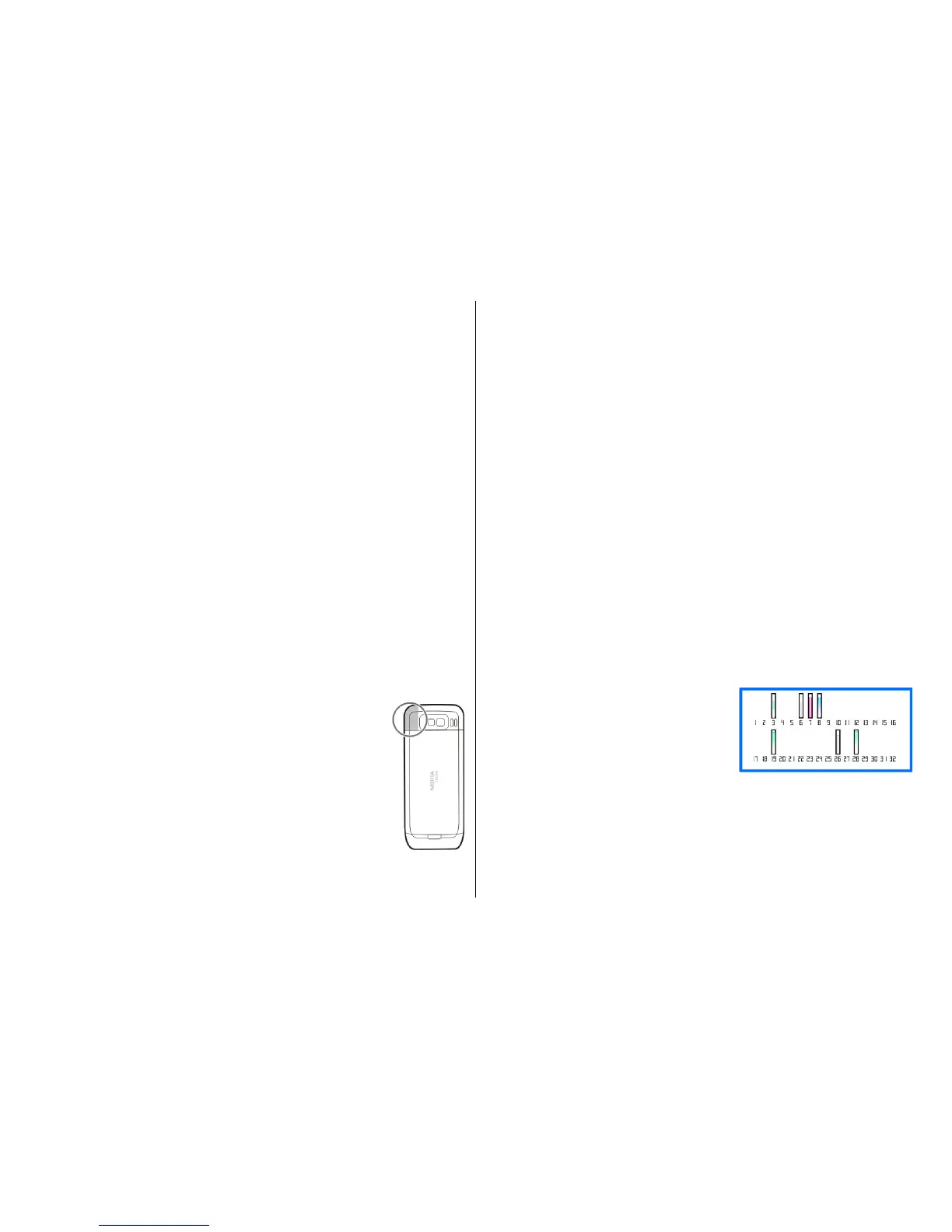
Hold your device correctly
The GPS receiver is located on the back of the device. When
using the receiver, make sure that you do not cover the
antenna with your hand.
Establishing a GPS connection may take from a
couple of seconds to several minutes.
Establishing a GPS connection in a vehicle may
take longer.
The GPS receiver draws its power from the device
battery. Using the GPS receiver may drain the
battery faster.
Tips on creating a GPS
connection
If your device cannot find the satellite signal, consider the
following:
• If you are indoors, go outdoors to receive a better signal.
• If you are outdoors, move to a more open space.
• Ensure that your hand does not cover the GPS antenna of
your device.
• If the weather conditions are bad, the signal strength may
be affected.
• Some vehicles have tinted (athermic) windows, which
may block the satellite signals.
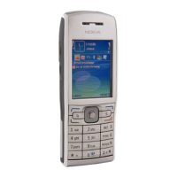
Check satellite signal status
To check how many satellites your device has found, and
whether your device is receiving satellite signals, select
Menu > Applications > GPS > GPS data and Options >
Satellite status.
If your device has found satellites,
a bar for each satellite is displayed
in the satellite information view.
The longer the bar, the stronger
the satellite signal is. When your
device has received enough data
from the satellite signal to calculate the coordinates of your
location, the bar colour changes.
Initially, your device must receive signals from at least four
satellites to be able to calculate the coordinates of your
location. When the initial calculation has been made, it may
© 2009 Nokia. All rights reserved. 77