Do you have a question about the B&G Triton2 and is the answer not in the manual?
Lists available documentation for the Triton2 system.
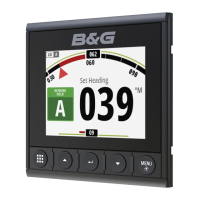
Manages data page selection and menu navigation.
Explains the function of Arrow, Enter, and MENU/Backlight keys for system navigation.
Covers powering the unit, initial setup wizard, and entering sleep mode.
Explains how to navigate and use the unit's menu structure for functions and settings.
Process for selecting, editing, and confirming numeric values in dialogs.
Adjusting backlight, display group, night mode, and color settings.
Configuring the unit as instrument only, autopilot display, or combined.
Enabling MOB page switching and displaying advanced autopilot settings.
Using the Pages key and arrow keys to choose a specific enabled data page.
Pressing the Pages key to cycle through all enabled data pages sequentially.
Automatic display of MOB event, showing position, range, and bearing.
Updates via AIS-SART or H5000 CPU dead reckoning for estimated position.
Selecting pages to be available via the Pages key.
Setting up automatic cycling through enabled pages at a defined interval.
Details the 16 standard data pages offered by the system.
Details the 13 template pages for creating user-defined page layouts.
Shows current autopilot mode, heading, and rudder indicators.
Visualizes key sailing data relative to the yacht's bow.
Options for tidal flow correction, target wind angle, and layline limits.
Customize which indicators appear on the SailSteer display.
Displays navigation data with a 3D boat position on the track.
Configures laylines with options for tidal flow and target wind angle.
Settings for tidal flow correction, grid, and target wind angle for laylines.
Graphically displays True Wind Direction and True Wind Speed over time.
Presents tidal information relative to the yacht's bow.
Shows weather data graphically, including barometer and air temperature.
Visualizes current depth and recorded depth data history.
Shows basic boat speed and depth with an acceleration bargraph.
Shows Apparent Wind Angle (AWA) and True Wind Speed (TWS).
Displays GPS position, course, speed, and waypoint data.
Visualizes apparent and true wind angles and speeds.
Shows AIS targets within the selected range and AIS mode.
Displays navigational data including compass heading.
Visualizes current and historical data plotted over a time scale.
Visualizes current and historical data plotted for two separate time scales.
Replacing existing pages with templates or selecting data for custom layouts.
Modifying the range scale for full screen analog data pages.
Using the race timer for countdowns to starts or elapsed time recording.
Details recording options for Trip 1 (water), Trip 2 (GPS), and overall Log.
Describes the layout of the AIS page, including own vessel and target representation.
Explains the meaning of various symbols used to identify AIS targets.
How to select targets using arrow keys and view details.
Adjusting display range, icon filters, and extension lines for better target visualization.
Accessing detailed information for a selected AIS target.
Viewing, sorting, and filtering the list of all received AIS targets.
How AIS messages are displayed on any page when vessel messages are enabled.
Accessing and viewing the complete list of received AIS messages.
How AIS SART beacons transmit data and are displayed on the system.
Defining alarms for target proximity, lost targets, and received messages.
Essential warnings and guidelines for safe autopilot use.
Details the functions of the LED, Port/Starboard, AUTO, MODE, and STBY keys.
Describes how to activate different autopilot modes using the MODE key.
Explains the LED indications for different autopilot modes and network alarms.
Details the information displayed on the autopilot page, including indicators and mode status.
Used for manual steering; switching to Non-Follow Up mode is possible.
Steers the vessel automatically to maintain a set heading without compensating for drift.
Performing controlled turns in AUTO mode by setting tack angle and time.
Steering the vessel to maintain a specific apparent or true wind angle.
Performing turns referencing wind angle, with adjustable tack parameters.
Steers the vessel along a calculated track line, compensating for drift.
Requires chartplotter connection and valid heading for navigation steering.
Steers to waypoints using chartplotter data; use in open waters is advised.
Manages automatic course changes at waypoints based on user-defined limits.
Configures the acceptable threshold for automatic course adjustments to next waypoint.
Configuration of alarms for system failures or sensor issues.
Details user-configurable settings for operational conditions and preferences.
Adjusts steering response levels affecting power usage and sensitivity.
Manually changing steering parameters configured during commissioning.
Adjusts steering parameters like turn rate, rudder gain, and autotrim.
Wind mode selection, VMG optimizing, and layline steering for sailboats.
Fine-tuning steering modes (Low, High, Wind) for rudder activity and steering feel.
Reducing rudder activity and sensitivity in rough weather.
Wind mode selection, VMG optimizing, and layline steering for sailboats.
How alarms are displayed, signaled, and cleared from the system.
Understanding alarm importance levels based on color coding.
Activating the alarm system and siren from the Alarms menu.
Configuring individual alarms and accessing the alarm history log.
Essential settings required for optimal system performance.
Configuring compatible HV displays to show desired Triton² data.
Adjusting for hull shape and paddlewheel for accurate speed and log readings.
Auto-calibration using GPS SOG compared to boat speed sensor.
Calibrating the log by performing runs over a specified distance reference.
Utilizing GPS Speed Over Ground as boat speed when paddle wheel data is unavailable.
Correcting for mechanical misalignment of the masthead unit.
Calibrating True Wind Angle by monitoring tack changes or using compass.
Refining TWS calibration by monitoring wind changes across different sailing angles.
Adjusting depth readings for transducer position relative to keel or surface.
Ensuring accurate heading reference by calibrating magnetic compasses.
Calibrating aft depth readings when a second depth device is available.
Compensating for differences between boat centerline and compass lubber line.
Manually initiating compass calibration by making a full turn.
Applying damping to make data appear more stable and less sensitive.
Controlling parameter settings globally or within specific unit groups.
Configuring units of measure for various data types.
Identifying network issues using the NMEA 2000 tab.
Viewing device details, software versions, and setting instance numbers.
Indicates bus power status and connection to data sources.
Monitoring Rx/Tx errors, messages, bus load, and fast packet errors.
Configuring network groups and units of measure for data display.
Adjusting backlight, display group, night mode, and invert day color.
Setting the unit as instrument only, autopilot display, or combined.
Enabling MOB page switching and displaying advanced autopilot settings.
Browsing unit's internal memory and connected device files.
Minimal required maintenance, cleaning the display unit properly.
Inspecting connectors and updating unit software via USB.
Accessing panel-specific functions and Race timer/Settings via the Page menu.
Accessing Race timer, Trip log, and sensor/system settings via the Settings menu.
Details on display size, type, resolution, and illumination.
Information on waterproof rating, humidity, and operating/storage temperatures.
Visual representation and measurements of the unit's width, height, and depth.
Definitions for common terms and abbreviations from A to M.
Definitions for common terms and abbreviations from M to X.
List of NMEA 2000 Parameter Group Numbers (PGNs) transmitted by the unit.
List of NMEA 2000 PGNs received by the unit from network devices.
| Resolution | 320 x 240 pixels |
|---|---|
| Interface | NMEA 2000 |
| Power Supply | 12V DC |
| Waterproof Rating | IPX7 |
| Backlight | LED |
| Display Size | 4.1 inches |
| Operating Voltage | 9 to 16V DC |