EasyManuals Logo

Clarion NX505E User Manual

Clarion NX505E
164 pages
To Next Page IconTo Next Page
To Previous Page IconTo Previous Page
Page #87 background imageLoading...
Page #87 background image
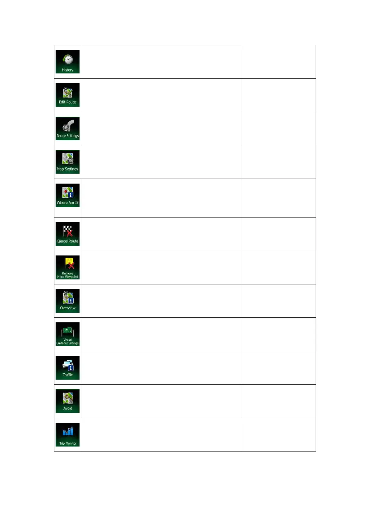
This button opens the History list. You can select one of
your previous destinations.
Find / History (page 58)
This button opens the route editing function.
My Route / Edit Route
This button opens the route related settings.
More / Settings / Route
Settings (page 88)
This button opens the map related settings.
More / Settings / Map
Settings (page 91)
This button opens a special screen with information
about the current posi
tion and a button to search for
nearby emergency or roadside assistance. For details,
see the next chapter.
Tap the Current Street
field on the Map screen
This button cancels the route and stops navigation. The
button is replaced with the next one if waypoints are
given.
My Route / Cancel Route
(page 66)
This button skips the next waypoint from the route.
n/a
This button opens a 2
D map scaled and positioned to
show the entire route.
My Route / Overview
(page 62)
This button opens the Visual Guidance settings screen.
More / Settings / Visual
Guidance (page 93)
This button opens the Traffic Summary screen.
Tap the Traffic icon in
the Navigation menu or
on the Map screen
This button lets you bypass parts of the recommended
route.
My Route / Avoidances
This button opens the Trip Monitor screen where you can
manage your previously saved trip logs and track logs.
More / Trip Monitor
(page 84)
22 NX505E English

Table of Contents

Questions and Answers:

Question and Answer IconNeed help?

Do you have a question about the Clarion NX505E and is the answer not in the manual?

Clarion NX505E Specifications

General IconGeneral
Widescreen-
Display diagonal6.2 \
Display resolution800 x 480 pixels
AM band range531 - 1602 kHz
FM band range87.5 - 108 MHz
Supported radio bandsAM, DAB, FM
Built-in cameraNo
Lifetime map updatesRoads change, but with Lifetime Map Updates your map will always be up to date. Start fresh every few months by downloading a new edition of the industry's most accurate map. New editions are issued four times per year.
Storage media typeMemory card
Compatible memory cardsMicroSD (TransFlash)
Product colorBlack
Weight and Dimensions IconWeight and Dimensions
Depth157 mm
Width178 mm
Height100 mm
Weight- g

Related product manuals