©
2019 DJI All Rights Reserved.
51
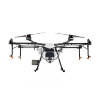
AGRAS T16
User Manual
*
The effective radar range varies depending on the material, position, shape, and other properties of the obstacle.
** To comply with local laws and regulations, this frequency is not available in some countries or regions.
DBF Imaging Radar
Model RD2418R
Operating Frequency
SRRC (China) / CE (Europe) / FCC (United States):
24.00 - 24.25 GHz
MIC (Japan) / KCC (Korea): 24.05 - 24.25 GHz
Power Consumption 15 W
EIRP SRRC: 13 dBm; MIC / KCC / CE / FCC: 20 dBm
Altitude Detection & Terrain Follow*
Altitude detection range: 1 - 30 m
Stabilization working range: 1.5 - 15 m
Max slope in Mountain mode: 35°
Obstacle Avoidance System*
Obstacle sensing range: 1.5 - 30 m
FOV: Horizontal: ±50°, Vertical: 0 - 10°
Working conditions: Flying higher than 1.5 m over the obstacle at
a speed lower than 7 m/s
Safety distance: 2.5 m (Distance between the front of propellers
and the obstacle after braking)
Obstacle avoidance direction: Forward or backward obstacle
avoidance depending on the direction of flight.
IP Rating IP67
FPV Camera
FOV Horizontal: 98°, Vertical: 78°
Resolution 1280×960 30 fps
FPV Spotlight FOV: 110°, Max brightness: 12 lux at 5 m of direct light
Flight Parameters
Operating Frequency
2.4000 - 2.4835 GHz
5.725 - 5.850 GHz**
EIRP
(EIRP)
2.4 GHz
SRRC / CE / MIC / KCC: < 20 dBm, FCC / NCC: < 26 dBm
5.8 GHz
SRRC / NCC / FCC: < 26 dBm
Total Weight (Excluding battery) 19.8 kg
Standard Takeoff Weight 41 kg
Max Takeoff Weight 42 kg (At sea level)
Max Thrust-Weight Ratio 1.975 (Takeoff weight of 41 kg)
Hovering Accuracy
(With strong GNSS signal)
D-RTK enabled: Horizontal: ±10 cm, Vertical: ±10 cm
D-RTK disabled:
Horizontal: ±0.6 m, Vertical: ±0.3 m (Radar module enabled:
±0.1 m)
RTK / GNSS Operating Frequency
RTK: GPS L1/L2, GLONASS F1/F2, BeiDou B1/B2, Galileo E1/E5
GNSS: GPS L1, GLONASS F1, Galileo E1
Battery DJI-approved battery pack (AB2-17500mAh-51.8V)

 Loading...