©
2022 DJI All Rights Reserved.
41
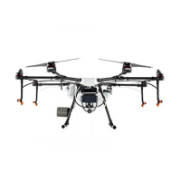
AGRAS T30
Unmanned Aircraft Flight Manual
3. Go to the home screen in the app, tap Plan Field, and select Walk with RTK.
4. Go to
, tap RTK to select the RTK source, and complete conguration. Wait until the system status
bar in the upper left corner of the screen turns green, indicating that RTK positioning is in use.
Plan a eld by following the instructions for walking with the remote controller below. Users can
also enter the Field Editing screen and use the crosshair to add boundary points and obstacles.
Refer to the Field Editing section for more information.
5. Walk with the remote controller alongside the boundary of the task area and tap Add Waypoint C2 or
press the C2 button on the remote controller at turning points.
6. Mark any obstacles:
Use one of the two methods below to mark any obstacles in or out of a target eld. Obstacles that are
marked outside of the task area during eld planning will be avoided when planning a connection
route for Connection Routing. Refer to Connection Routing for more information.
①
Tap Obstacle Mode C1 onscreen or press the C1 button on the back of the remote controller.
Next, walk with the remote controller around the obstacle and tap Add Obstacle C2 onscreen or
press the C2 button to add points for the obstacle. Finally, tap Waypoints Mode C1 or press the
C1 button when nished.
②
Tap Obstacle Mode C1 onscreen or press the C1 button on the back of the remote controller.
Next, walk with the remote controller to the obstacle, and then tap Round. A red circle will appear
on the map. Tap the center of the circle to select the obstacle and drag to adjust the position.
Select the red point on the circumference of the obstacle and drag to adjust the radius. Finally,
tap Waypoints Mode C1 or press the C1 button when nished.
7. Continue measuring the field by walking with the remote controller alongside the boundary and
adding waypoints at each corner of the field. Tap Done when the field has been measured and
all obstacles have been marked. The app produces a ight route according to the perimeter and
obstacles of the eld.
8. Add prescription map: tap
on the screen and select a prescription map from the list for a preview.
Each area of the field on the map will be displayed in a color corresponding to the amount of
material. Tap Yes to apply the selected prescription map to the eld included in the map. Users can
also add a prescription map while editing a eld or before performing an operation.
9. Calibration points can be added when Rectify Offset is enabled in
under .
Add calibration point: Walk with the remote controller to the location of each calibration point. Tap
Calibration Point onscreen.
The calibration points are used to offset the bias of the flight route caused by the positioning
difference. Choose at least one existing landmark as the xed reference point for calibration when
executing the same operation. If none are available, use an easily identiable object such as a metal
stake.
Walk with RC
Users should walk along the boundary of the field or the obstacles with the remote controller for
measurements. Make sure that the aircraft is powered off when planning your ight route.
1. Power on the remote controller and enter DJI Agras. Tap Plan Field and select Walk with RC.
2. Wait until the GNSS signal is strong. Positioning accuracy may vary by +/-2 meters. Complete the
remaining steps by walking with the remote controller following the same instructions as the Walk with
RTK section.

 Loading...