Currentstationinformation
Dependingonyourcartography
,Currentstationinformationmaybeavailable.
Currentstationsymbol
Currentstationlocationsaremark
edonthechartusinga
diamond-shapedsymbolwitha‘C’inthemiddle.
•ThesymboliscoloredBluewhenusingapplicableNavionics
cartography.
•ThesymboliscoloredBlackwhenusingapplicableC-Map
cartography.
Dynamiccurrentgraphic
UsingNavionicscartography ,whentheTidesoptionisenabled([Menu
>Settings>Set-up>Tides]),thecurrentstationsymbolisreplacedwith
adynamiccurrentgraphic:
Thedynamiccurrentgraphicisanarrowpointinginthe
directionofcurrentflow.Arrowlengthindicatesthespeedof
thecurrent;thelongerthearrow,thefasterthespeed.
Thearrow’sborderindicatescurrentstatus:
•Red=increasingcurrentspeed.
•Blue=decreasingcurrentspeed.
Currentspeedisshowninsidethearrow.Currentspeedis
displayedinuser-selectedspeedunits,withdecimalsdisplayed
insubscript.Decimalsarenotshownforvaluesof10orgreater.
Iftidalconditionsare“slack”,theword“SLACK”appearsina
boxwithaBlueborder.
WhenusingC-Mapcartography ,arrowsareusedtoindicatethedirection
ofcurrentflow.Thesizeandcolorofthearrowindicatesthestrengthof
thecurrent:
ColorSpeed
1Yellow
0to0.1Knots
2
Y
ellow
0.2to1.0Knots
3Orange1.1to2.0Knots
4
Orange2.
1to3.0Knots
5R
ed
>3.0Knots
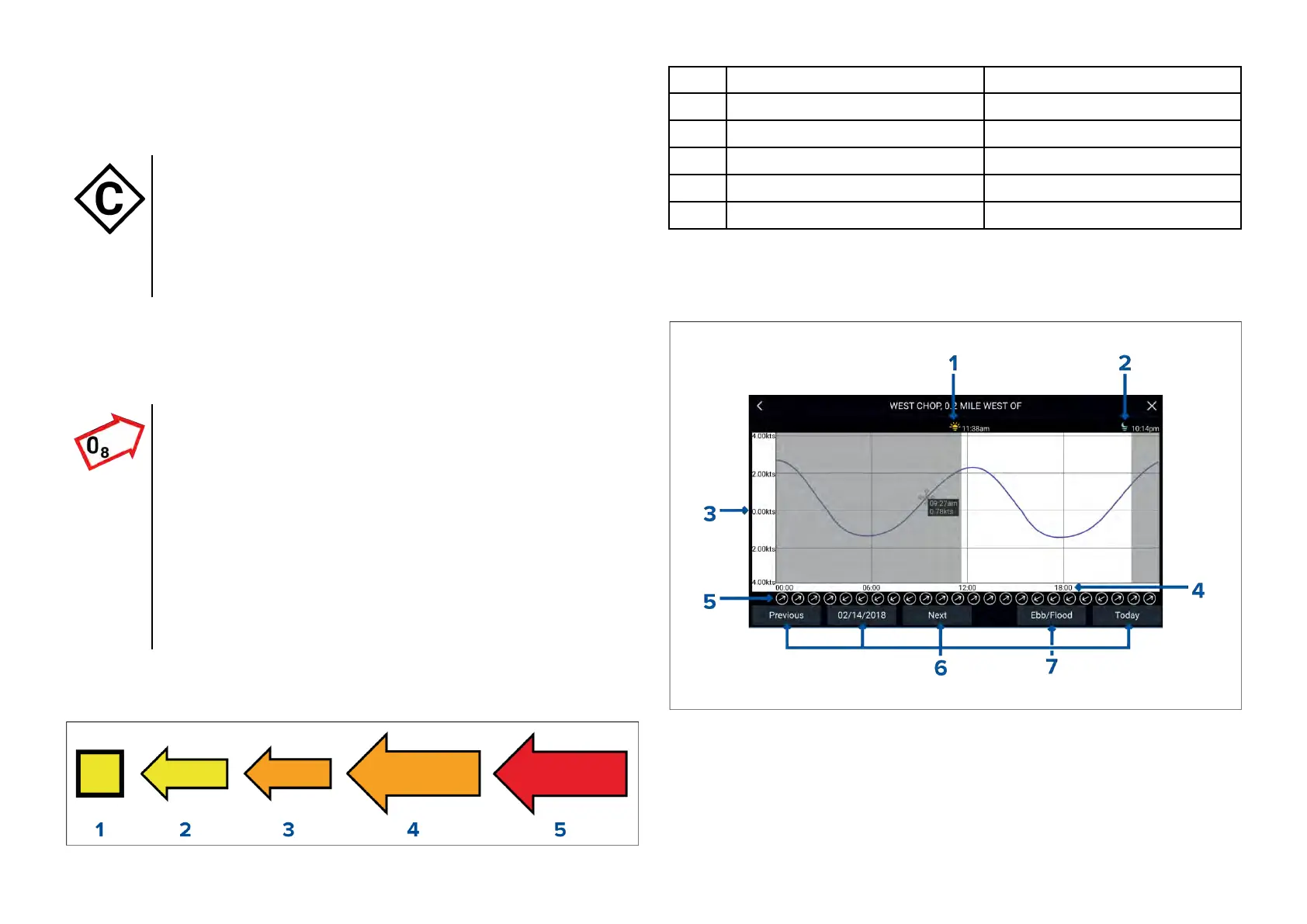
Currentgraph
Currentgraphsareavailablebyselecting[moreoptions]andthen[Current
station]fromthecurrentstation
’scontextmenu.
1.Sunrise—Indicatestimeofsunrise.
2.Sunset—Indicatestimeofsunset.
3.Speed—Providescurrentspeedinselectedunits.
4.Time—Indicatestimeofday.
Chartapp
85