Do you have a question about the Suunto AMBIT and is the answer not in the manual?
Describes symbols like WARNING, CAUTION, NOTE, and TIP used in safety information.
Lists critical precautions for device use and health, including allergic reactions and consulting a doctor.
Explains symbols representing device functions and status, such as barometer, GPS, and battery.
Describes the primary and long-press actions of each button for device operation.
Details on activating the backlight and locking/unlocking device buttons.
Instructions for charging the device via USB or a compatible wall charger.
Steps to connect the device to the Movescount online platform for data management.
Process for performing software updates on the Suunto Ambit device.
Creating and using personalized exercise displays and modes.
How to switch between light and dark screen modes for better visibility.
Accessing and modifying the device's time and date settings.
Step-by-step guide for adjusting the clock and calendar on the device.
Configuring a second time zone display for tracking different regions.
How to set up the device's alarm clock functionality.
Actions to take when the alarm sounds, including Snooze and Stop.
Introduction to the device's Global Positioning System capabilities for location tracking.
Guidance on acquiring a satellite signal for accurate location services.
Understanding coordinate systems and display options for GPS positioning.
Finding and displaying the current GPS coordinates on the device.
Saving current locations as named points or 'waypoints' on the device.
Following a saved location using the device's GPS navigation features.
Removing saved locations or 'waypoints' from the device's memory.
Explanation of the principles behind altitude and barometric pressure measurement.
Calibration methods and tips for obtaining accurate altitude and pressure readings.
Common causes for inaccurate altitude and pressure measurements and how to avoid them.
Selecting the appropriate Altimeter or Barometer profile for different activities.
Configuring the Automatic, Altimeter, or Barometer modes on the device.
Inputting known altitude or sea level pressure for accurate calibration.
Features and views available when the Altimeter profile is active.
Features and views available when the Barometer profile is active.
How the device automatically switches between Altimeter and Barometer modes.
Steps to ensure accurate compass readings by performing calibration.
Adjusting the device for magnetic north variation to improve accuracy.
Types of predefined and custom exercise modes available for different sports.
Customizing settings and options during an active exercise session.
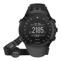
Connecting and using a heart rate monitor for enhanced exercise data.
Resolving common issues related to heart rate detection and signal loss.
Proper placement and adjustment of the heart rate strap for optimal performance.
Initiating and configuring an exercise session, including selecting modes and sensors.
Features and interactions available while an exercise session is in progress.
Logging the route taken during an exercise using GPS data.
Manually or automatically creating lap splits to track performance segments.
Logging altitude changes and elevation data during activities.
Viewing post-exercise data and summaries after completing a session.
Details included in the summary when a heart rate belt was used during exercise.
Details included in the summary when no heart rate belt was used.
Configuring personal details like weight, max HR, and general preferences.
Adjusting dual time, alarm, date format, and display appearance (tones, invert).
Configuring compass calibration, declination, and GPS formats.
Setting Alti/Baro profiles, reference values, and pairing accessories.
How to change the screen contrast level for optimal readability.
Performing an LCD test to check screen functionality and integrity.
Putting the device into power-saving mode to conserve battery life.
Troubleshooting steps for GPS issues, including resetting GPS data.
Steps to connect external sensors like HR belts and PODs to the device.
Solutions for failed heart rate belt connection attempts.
Adjusting bike PODs for accurate speed and distance measurement.
Visual symbols representing device features and status indicators.
Symbols used to mark different types of saved locations on the map.
Information on the device's water protection rating and usage limitations.
Procedures and tips for recharging the device's battery for optimal lifespan.
Instructions for changing the battery in the heart rate belt.
Operating conditions, weight, memory capacity, and ANT communication details.
Measurement ranges and resolution for barometer and altimeter functions.
Information on regulatory compliance (FCC, CE, RSS) and copyright.
Information regarding product patents and intellectual property.
Details on the limited warranty period, coverage, and exclusions.
| Waterproof | Yes |
|---|---|
| Product color | Black |
| Waterproof up to | 100 m |
| Market positioning | Sport watch |
| Protection features | Water resistant |
| Clock mode | 12h/24h |
| Electronic compass | No |
| Recommended activity | Running |
| Heart rate data transfer | Ant |
| Number of waypoints | 100 |
| Display type | Digital |
| Display technology | Dot-matrix |
| Storage temperature (T-T) | -30 - 60 °C |
| Operating temperature (T-T) | -20 - 60 °C |
| Languages support | DEU, DUT, ENG, ESP, FIN, FRE, ITA, POR, SWE |
| Weight | 78 g |
|---|---|
| Dimensions (WxDxH) | 50 x 50 x 18.1 mm |