Do you have a question about the Topcon ES-52 and is the answer not in the manual?
Explains the various symbols and conventions used throughout the manual for clarity.
Provides context and notes on the style and conventions employed in the manual.
Defines the meaning of warning symbols (WARNING, CAUTION) and instructional symbols.
Covers general safety guidelines for using the instrument and its accessories.
Highlights safety measures related to the battery charger and power supply.
Details safety precautions when mounting and using the instrument on a tripod.
Specifies precautions for charging the battery, including temperature ranges and procedures.
Outlines measures to maintain waterproofing and dust resistance of the instrument.
Covers various other precautions for instrument handling, storage, and operation.
Details instrument maintenance procedures and regulations regarding product export.
Classifies the instrument's laser components according to safety standards.
Provides critical warnings and precautions for safe laser operation.
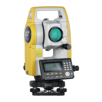
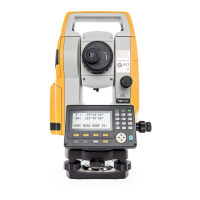
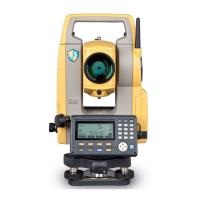
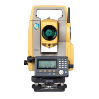
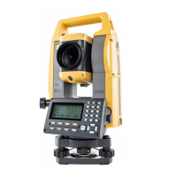
Identifies and describes the various external parts and components of the ES instrument.
Illustrates the different operational modes and their interconnections within the instrument.
Explains fundamental operations such as powering on/off and key functions.
Details how to use softkeys and input letters or figures on the instrument.
Describes how to select options and navigate between different operational modes.
Explains the various screens and displays, including status, OBS, measuring, and input screens.
Details how to use the Star Key mode for common measurement settings.
Provides instructions and precautions for charging the instrument's battery.
Explains the procedure for correctly installing and removing the battery.
Details the steps for centering the instrument over a survey point using the optical plummet.
Explains the process of leveling the instrument using circular and electronic levels.
Guides on how to focus the telescope and sight the target accurately.
Explains the concept of parallax and how to remove it for accurate measurements.
Details the steps for turning the instrument on, including password entry.
Explains the procedure for safely turning off the instrument.
Describes how to measure the included angle between two points by setting horizontal angle to 0°.
Explains how to set a specific horizontal angle value (hold) for new measurements.
Covers angle measurement and how to output the collected data to external equipment.
Outlines necessary settings and precautions before performing distance measurements.
Details how to check the strength of the returned signal for accurate measurements.
Explains how to perform simultaneous distance and angle measurements.
Describes how to recall and display previously measured distance and angle data.
Covers coordinate measurement and outputting the collected coordinate data.
Explains the Remote Elevation Measurement (REM) function for measuring heights.
Details the procedure for entering instrument station coordinates and azimuth angle.
Explains how to load and use previously registered coordinate data for setup.
Describes how to determine instrument station coordinates using resection.
Provides important precautions and guidelines for performing resection measurements.
Details the procedure for measuring and calculating 3D coordinates of a target point.
Explains the purpose of setting-out measurement and calculation formulas.
Describes the procedure for setting out points based on coordinate data.
Explains how to set out points using horizontal angle and distance.
Details the procedure for setting out points using the REM measurement function.
Explains how to define a baseline by inputting or observing points.
Describes how to find point coordinates by inputting length and offset based on the baseline.
Details methods for offsetting the baseline in three dimensions.
Explains how to determine horizontal and vertical offsets from a baseline.
Explains methods for defining an arc by inputting parameters or observing points.
Describes how to find coordinates of points along an arc using length and offset.
Details methods for offsetting the arcline in three dimensions.
Explains how to define a baseline, which is essential for point projection.
Describes the procedure for projecting a point onto a defined baseline.
Details the preliminary settings required for topography observation.
Explains the steps for performing standard topography observations.
Guides on how to conduct reflectorless (RL) topography observations.
Describes measuring distance and angle to a point by offsetting.
Explains how to find a target's included angle using offset points.
Details measuring target points using distances to two offset points.
Explains how to find distance/coordinate of a plane edge where direct measurement is difficult.
Describes how to find the center coordinates and azimuth of a column.
Explains measuring distances between points without moving the instrument.
Details how to calculate missing line measurements using input coordinates.
Describes how to change the starting point for subsequent missing line measurements.
Explains calculating area by observing points sequentially around the area.
Describes calculating area by inputting or reading known point coordinates.
Details the procedure for finding intersection points based on reference points.
Highlights conditions under which intersection points cannot be calculated.
Guides on performing traverse measurements and recording results.
Explains how traverse precision (closure errors) is displayed after calculation.
Details various methods for adjusting traverse data (Compass, Transit, Angular, Elev).
Describes the function that searches for and presents potential traverse routes.
Covers setting the instrument and backsight stations for route surveying.
Explains how to calculate center and width pegs for straight lines.
Details calculation of center and width pegs for circular curves.
Explains calculation of center and width pegs for spiral (clothoid) curves.
Describes calculation of center and width pegs for parabolic curves.
Explains calculation based on three input points for curves.
Covers calculation of intersection and azimuth angles related to route curves.
Details the procedure for inputting intersection points for route calculation.
Explains how to preset curve types and connection points for automatic calculation.
Describes how to find coordinates of arbitrary points on calculated curves.
Explains finding route widths and coordinates using inverse width peg calculation.
Provides an overview of route calculation, including curve types and limits.
Details the procedure for measuring and setting out points along road cross-sections.
Explains how to select observation directions (patterns) for cross-section surveys.
Describes how to review cross-section data recorded in a JOB.
Explains how to define a baseline connecting two points for point to line measurement.
Guides on measuring target points relative to a defined line.
Details how to record instrument station coordinates and related data.
Explains how to record backsight station data and azimuth angle.
Describes how to store angle measurement data in the current JOB.
Explains how to store distance measurement data in the current JOB.
Details how to store coordinate measurement data in the current JOB.
Covers storing both distance and coordinate data simultaneously for the same point.
Explains how to prepare and record notes data in the current JOB.
Describes how to display and review data stored within the current JOB.
Explains how to delete recorded data from the currently selected JOB.
Covers registering and deleting coordinate data for known points in the current JOB.
Explains how to save, read, and delete codes used for data recording.
Describes how to display all coordinate data within the current JOB.
Details the procedure for transferring JOB data to a host computer via serial connection.
Explains how to output code data to a host computer, specifying communication settings.
Explains the various configuration settings available in the Config Mode.
Details the two display methods for horizontal distance: Ground and Grid.
Explains the automatic tilt angle compensation mechanism using the 2-axis tilt sensor.
Describes the collimation correction function for horizontal angle errors.
Explains sea level correction for horizontal distance, recommending spherical correction at high altitudes.
Details settings related to power off, reticle, contrast, resume, and EDM ALC.
Covers settings for communication parameters like baud rate, data bits, and parity.
Explains settings for temperature, pressure, angle, and distance units.
Details settings for the Electronic Distance Measurement (EDM) system.
Explains how to calculate and input atmospheric correction factors.
Describes how to set the prism constant correction value for reflective prisms.
Explains how to customize softkey allocations for efficient operation.
Guides on saving and loading custom softkey configurations (User 1, User 2).
Details the procedure for changing the instrument's password.
Explains methods for restoring factory default settings and initializing data.
Lists error messages related to poor measuring conditions or inability to sight targets.
Describes errors related to calculation failures or data transmission issues.
Explains errors related to the lithium battery, clock, and communication with external devices.
Covers errors like flash write failure, incorrect passwords, and invalid baselines.
Lists errors related to memory capacity and incomplete observations (1st/2nd obs, offset, prism).
Details errors occurring when measurements exceed specified ranges or limits.
Covers errors like 'Pt already on route', 'Same coordinates', and 'Station coord is Null'.
Provides steps for checking and adjusting the circular level for accurate leveling.
Explains how to check and cancel tilt zero point errors using the tilt sensor.
Describes how to measure collimation error to correct subsequent observations.
Details checks for reticle perpendicularity and vertical/horizontal line positions.
Guides on checking and adjusting the optical plummet for accurate centering.
Explains how to check if the additive distance constant is close to zero.
Lists the standard components included with the instrument.
Describes optional accessories available for the ES instrument.
Details the various prism systems and adapters available for use.
Lists compatible batteries, chargers, and power cables for operating the instrument.
Provides technical details about the instrument's telescope.
Details accuracy, units, and modes for angle measurements.
Lists specifications for the tilt sensor and compensation features.
Provides details on measuring method, signal source, range, and accuracy.
Includes overall specifications for display, operation panel, and environmental resistance.
Explains the procedure for manually indexing the vertical circle for high precision angle measurements.
Details how the instrument accounts for refraction and earth curvature in distance calculations.
Provides FCC compliance information for Class A digital devices in the USA.
Highlights warnings related to California regulations and battery materials.
Covers compliance with Canadian Interference-Causing Equipment Regulations and EU directives.
Details compliance with Chinese environmental standards and EU battery regulations.
| Model | ES-52 |
|---|---|
| Category | Measuring Instruments |
| Type | Electronic Total Station |
| Telescope Magnification | 30x |
| Internal Memory | 10, 000 points |
| Operating Temperature Range | -20°C to +50°C |
| Waterproof/Dustproof | Yes |
| IP Rating | IP66 |
| Angle Accuracy | 5 arc seconds |
| Distance Range Reflectorless | 500 m |
| Distance Measurement Range | 0.3 m to 500 m (Reflectorless) |
| Compensator | Dual-axis |
| Display | LCD |
| Battery Life | Approx. 14 hours |
| Communication | USB |