Turning On the A-Scope
NOTE: This feature is available in the Traditional sonar views.
The a-scope is a vertical flasher along the right side of the view, showing you what is underneath the transducer
right now. You can use the a-scope to identify target returns that may be missed when the sonar data is
quickly scrolling across the screen, such as when your boat is moving at high speeds. It can also be helpful for
detecting fish that are close to the bottom.
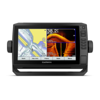
The a-scope above shows fish returns and a soft bottom return .
From a sonar view, select Menu > Sonar Setup > Appearance > A-Scope.
Panoptix Sonar Setup
Adjusting the RealVü Viewing Angle and Zoom Level
You can change the viewing angle of the RealVü sonar views. You can also zoom in and out of the view.
From a RealVü sonar view, select an option:
• To zoom in and out, select and .
• To adjust the viewing angle on devices with keys, use the arrow keys.
• To adjust the viewing angle diagonally on touchscreen devices, select .
• To adjust the viewing angle horizontally on touchscreen devices, select .
• To adjust the viewing angle vertically on touchscreen devices, select .
Adjusting the RealVü Sweep Speed
You can update how quickly the transducer sweeps back and forth. A faster sweep rate creates a less detailed
image, but the screen refreshes faster. A slower sweep rate creates a more detailed image, but the screen
refreshes more slowly.
NOTE: This feature is not available for the RealVü 3D Historical sonar view.
1 From a RealVü sonar view, select Menu > Sweep Speed.
2 Select an option.
Sonar Fishfinder 69