GNS 430 Pilot’s Guide and Reference
SECTION 3
NAV PAGES
3-24
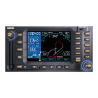
3.9 VERTICAL NAVIGATION PAGE
The GNS 430’s Vertical Navigation Page (the last NAV
page, see Figure 3-48) creates a three-dimensional profile
to provide guidance from the present position and altitude
to a final (target) altitude at a specified location. This is
helpful when descending to a certain altitude near an
airport or climbing to an altitude before reaching a route
or direct-to waypoint (Figure 3-49). Once the profile is
defined, message alerts and additional data on the Default
NAV Page and the Map Page provide guidance to the
pilot.
Figure 3-48 Vertical Navigation (VNAV) Page
6
5
1
4
3
2
8
7
9
Target Altitude
1
Target Distance
2
Altitude Reference (AGL or MSL)
3
Target Reference
4
Vertical Speed Desired
5
Vertical Speed Required
6
Current Page Group
7
Number of Pages in Current Page Group
8
Positon of Current Page within Current
Page Group
9
NOTE: To use the vertical navigation features,
ground speed must be greater than 35 knots
and the pilot must be navigating to a direct-to
destination or using a flight plan.
Figure 3-49 Vertical Navigation Profile
To create a vertical navigation profile
(Figure 3-49):
1) Press the small right knob to activate the
cursor.
2) Turn the large right knob to highlight the
target altitude field.
3) Turn the small and large right knobs to select
the target
altitude (Figure 3-50) and press the
ENT Key.
Figure 3-50 Target Altitude Field Selected