26 27
FUNCTIONAL CHARACTERISTICS
This chapter describes some of the most important functions
of the GEONAV, as well as the terms most commonly used in
this document.
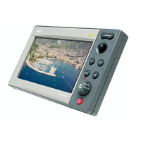
Switching on/Switching off the unit
To switch the GEONAV on, press the PWR key. To switch it
off, keep the PWR key pressed for more than 3 seconds.
Welcome page
At start-up, the GEONAV displays a welcome page whose text
(e.g., the boat’s name) can be edited by the Setup menu (see the
Setup Section). To freeze the page displayed, press PAGE. To
unfreeze the page and continue with the instrument’s opera-
tion, press PAGE again.
Standard/Advanced modes
The GEONAV can operate in Standard mode or in Advanced
mode. In Advanced mode, even the less frequently used func-
tions, such as data saving to cartridges and heading/speed
filters, are available. In Standard mode, some menus feature
less options, thus making it easier to use the plotter. To choose
the operating mode desired, press the PAGE key to display the
menu, select SETUP and then SELECT MODE.
Depth sounder
If connected to a depth sounder via NMEA, the GEONAV will
enable the depth sounder mode, showing a graph of the sea
bed or the relevant data in numerical form.
The depth value can be expressed in meters (default value),
feet or fathoms; to select the unit, press PAGE to display the
menu, select SETUP and DEPTH UNITS (M/FT/FA).
Sailing functions
If connected to a mast head transducer (anemometer), the
GEONAV will automatically enable the Sailing mode, once wind
speed and direction data has been received.
Sailing
tion mode.
5 - Route leg
Part of route between two waypoints.
6 - Waypoint
Waypoints are identified by a circle and a number. The route
starting point is marked by the “X” symbol. The target waypoint
is identified by a filled circle, whereas the route leg currently
followed is identified by a thicker line.
7 - Cursor
Indicates the position expressed in geographical coordinates
(latitude and longitude).
It is displayed when the plotter is in Cursor mode.
8 - Heading vector
Indicates graphically the boat’s current route.
9 – North indicator
Indicates the north direction when the Chart rotation func-
tion is enabled.
10 – True wind vector
Indicates the direction of true wind detected by onboard in-
struments.
11 – Layline
Indicates the direction after the next tack or gybe. In order to
achieve the best performance, the tack or gybe should be car-
ried out as soon as the layline crosses the target waypoint.
Sailing
Graphic Items Functional Characteristics