104
DIGITAL INTERFACE (IEC61162-1)
14
■ I/O Sentences
D Version number
IEC61162-1 Ed.5(2016-08)
D Input sentences (IEC61162-1)
RMC, GGA, GNS, GLL, and VTG
D Input sentence description
• RMC—Recommended minimum specic GNSS data
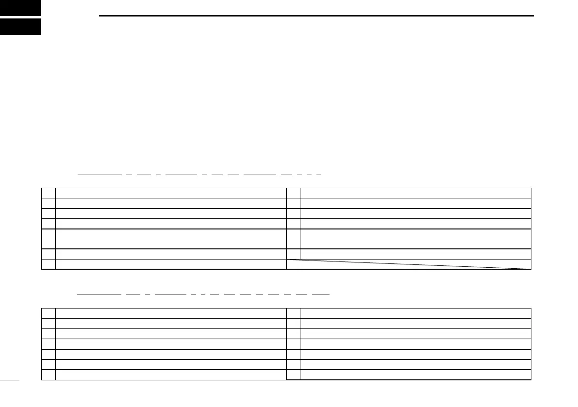
$**RMC, hhmmss.ss, A, llll.ll, a, yyyyy.yy, a, x.x, x.x, ddmmyy, x.x, a, a, a*hh<CR><LF>
1 2 3 4 5 6 7 8 9 10
11 12 13
1 UTC of position x (000000.00 to 235959.99) 8 Course over ground, degrees true (0.0 to 360.0)
2 Status (A=data valid, V=navigation receiver warning) 9 Date (010100 to 311249)
3 Latitude (0000.0000 to 9000.0000) 10 Magnetic variation, degrees (no use)
4 N/S 11 E/W
5 Longitude (00000.0000 to 18000.0000) 12
Mode indicator (A=Autonomous, D=Differential, F=Float RTK,
N=No x, P=Precise, R=Real Time Kinematic, S=Simulator mode)
6 E/W 13 Navigational status indicator (no use)
7 Speed over ground, knots (0.0 to 100.0)
• GGA—Global positioning system (GPS) fix data
$**GGA, hhmmss.ss, llll.ll, a, yyyyy.yy, a, x, xx, x.x, x.x, M, x.x, M, x.x, xxxx*hh<CR><LF>
1 2 3 4 5 6 7
8 9 10 11 12
13
14
1 UTC of position (000000.00 to 235959.99) 8 Horizontal dilution of precision (no use)
2 Latitude (0000.0000 to 9000.0000) 9 Antenna altitude above/below mean sealevel (no use)
3 N/S 10 Unit M
4 Longitude (00000.0000 to 18000.0000) 11 Geoidal separation (no use)
5 E/W 12 Unit M
6 GPS quality indicator (1 to 5) 13 Age of differential GPS data (no use)
7 Number of satellites in use (no use) 14 Differential reference station ID (no use)
 Loading...