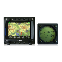
LX 10k
Device setup
Document name: LX 10KUM
Document revision: R1
5.1.7.1 Airspace
The airspace sub-menu holds the settings for colour and transparency of the fill and outline for
the following airspace types:
• Controlled zone
• Prohibited
• Restricted
• Danger
• Terminal area
• Airway
• Glider
• Military
• Other
• Class A, B
• Class C
• Class D
• Class E
• Class F
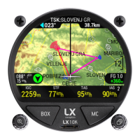
5.1.7.2 Map
The Map sub-menu holds settings for the graphical appearance of the Map are on all navigation
pages. The following settings are available.
• Orientation - offers the two common map orientations - ’North up’ and ’Track up’.
• Color palette - offers the pilots different color palettes to choose from for the map altitude
defined coloring. Different color palettes are shown below.
• TP/APT text size - changes the size of airports and turnpoints names on the map.
• TP/APT text color - changes the color of airports and turnpoints on the map.
• Dest. line colour - the colour of the line connecting your current position and your navi-
gation point.
• Track line colour - the colour of the line showing your current true track.
• Display Terrain - whether or not to show the color-coded terrain elevation.
• Display tail - whether or not to show the tail of the aircraft (tail representing your past
track).
• Display APT names - whether or not to display airport names (alongisde the icon) on the
map.
• Display TP names - whether or not to display turnpoint names (alongside the icon) on the
map.
The LX 10k incorporates terrain elevation information for the whole world (as much as provided
by NASA satellites, limited availability in the far North and South). Based on this info, the terrain
elevation is shown with the following color palettes:
Device manual Public 60