Do you have a question about the LX Navigation LX8000 and is the answer not in the manual?
Details the two-year warranty for defects in materials or workmanship.
Lists the components included with the LX8000 when the Flarm option is present.
Lists the components included with the LX8000 when the Flarm option is absent.
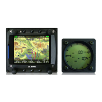
An overview of the LX8000 instrument, its units, and key features.
Details the features of the LX8000's color display, operating system, and controls.
Describes the capabilities and functions of the LX8000 vario unit.
Explains the various interfaces available for data transfer and external devices.
Details internal and external options, including Flarm and accessories.
Provides technical specifications such as power input, consumption, and dimensions.
Lists the weight of the LX8000 digital and vario units.
Details the LX8000's rotary switches, push buttons, and their functions.
Explains the procedure for powering on the LX8000 system.
Describes the LX8000's user interface elements for inputting data.
How to input alphanumeric strings using the text editor.
Using the masked editor for specific character input like coordinates.
Adjusting numeric parameters using spin controls for increase/decrease.
Selecting values from predefined lists using selection boxes.
Enabling or disabling parameters using checkboxes.
Setting colors and transparency for map elements.
Details the recommended methods for safely shutting down the LX8000.
Allows configuration of LX8000 settings like QNH, units, and hardware.
Displays GPS status, altitude, flight level, sunrise, and sunset.
Lists landable waypoints and airports sorted by arrival altitude.
Shows statistical data for flights in progress or stored in the logbook.
Enables navigation to and selection of airports from the LX navigation database.
Allows navigation to and editing of waypoints stored in selected files.
Facilitates task creation, manipulation, and navigation to selected turnpoints.
Sets QNH, safety altitude, magnetic variation, and ETA calculation.
Adjusts QNH pressure to offset altitude datum changes during flight.
Sets the altitude reserve added to final glide altitude.
Configures magnetic variation for navigation calculations.
Selects methods for calculating Estimated Time of Arrival/Elapsed.
Defines the start time of soaring for flight optimization.
Details the IGC-approved flight recorder and its settings.
Configures vario needle filter, sound filter, range, integrator time, and Auto SC.
Controls screen brightness and automatic brightness adaptation.
Manages waypoint, airspace, and airport databases via SD card or USB.
Loading user airspace and waypoint files from SD card or USB stick.
Loading official LX navigation airspace and airport databases.
Viewing, selecting, and deleting airspace databases/files.
Selecting, activating, and deleting waypoint files.
Viewing and managing the airport database.
Viewing and managing stored flight logs.
Formatting the SD card for compatibility with LX8000.
Configures map appearance, including terrain, airspace, and waypoints.
Setup for map display, terrain rendering, and map element appearance.
Configures the display and presentation of airspace zones on the map.
Customizes the look and feel of waypoint labels and symbols on the map.
Sets display options for flown path, current track, and target vectors.
Configures how optimized distance and FAI triangle calculations are displayed.
Sets up how tasks and observation zones are drawn in graphical pages.
Configures the presentation of the Flarm radar display.
Configures audio settings for vario, voice module, and alarms.
Sets up audio modes for climb and cruise (SC) modes.
Configures voice module settings, including volume and message selection.
Sets up audio alarms for specific events and warning delays.
Defines default geometry for start, turnpoint, and finish zones.
Sets parameters for calculating optimized flown distance according to OLC/FAI rules.
Configures airspace, altitude, and Flarm warnings.
Sets up airspace warnings based on proximity and projected path.
Configures altitude warnings based on projected altitude.
Defines which Flarm data is presented by the voice module.
Sets units for distance, speed, altitude, and ballast input.
Manages pilot profiles for different gliders or flying locations.
Sets hardware properties like TE compensation, LCD layout, and compass.
Configures vario settings such as TE compensation and filters.
Configures secondary LCD vario indicators and their displayed parameters.
Details compass installation, calibration, and parameter settings.
Setup for Flarm operation modes, frequency, and competition mode.
Configures NMEA output for GPS, LX8000, and Flarm data.
Enters glider polar data and properties for performance calculations.
Provides access to specific procedures and settings via passwords.
Displays GPS status, altitude, flight level, sunrise, and sunset.
Lists landable waypoints and airports sorted by arrival altitude.
Shows statistical data for flights in progress or stored in the logbook.
Accesses and manages stored flight logs.
Displays flight statistics, task statistics, and last 60 minutes data.
Enables navigation to and selection of airports from the LX navigation database.
Displays GPS status, mode, relative bearing, local time, and battery status.
Interprets the final glide symbol showing arrival altitude and glide path.
Provides visual cues for thermal strength and direction.
Shows additional navigation data including current track and groundspeed.
Displays altitude, OAT, and battery voltage.
Shows ETA, ETE, airport frequency, and runway information.
Explains functions assigned to navigation buttons and remote stick.
Procedure for selecting an airport for navigation.
Adjusting MacCready, ballast, and bugs for flight performance.
Configuring map orientation, zoom, and displayed items.
Calculates and displays wind data based on different methods.
Displays airspace zones in the vicinity and their status.
Rotates the FAI triangle assistant to match position.
Modifying attributes of an existing waypoint.
Adding a new waypoint, optionally copying from airport database.
Facilitates task creation, manipulation, and navigation to selected turnpoints.
Creating and manipulating tasks, editing points and task time.
Step-by-step guide to creating a new task by adding turnpoints.
Adjusting observation zone geometry for task points.
Setting task specific options like finish altitude.
Saving a completed task to the active waypoint file.
Loading stored tasks from active waypoint files.
Moving points within assigned areas to adjust task length.
Details the vario's electronic filters and their effect on indication.
Provides information on the temperature-compensated altimeter.
Steps for recalibrating the barogram sensor for IGC compliance.
Explains the MacCready theory and visual indicators for speed command flying.
Details the final glide calculator and factors affecting its accuracy.
Procedures before takeoff: power on, profile selection, and elevation setup.
Steps to power on the LX8000 and its welcome screen sequence.
Selecting the appropriate pilot profile for the current flight.
Crucial step for setting elevation and QNH for final glide calculation.
Recommends checking MacCready, ballast, and bugs settings.
Guidance on preparing tasks before takeoff to avoid errors.
Explanation of Assigned Area Tasks (AAT) and their structure.
Instructions for executing tasks during flight.
Procedure for starting a task, including entering the start zone.
How to restart a task if it was abandoned.
Handling turnpoints and advancing to the next point in a task.
Procedure for entering and navigating within assigned areas.
Moving points within assigned areas to adjust task length.
Automatic task completion upon entering the finish zone.
Steps to follow immediately after landing for proper shutdown and data saving.
Instructions for mounting the LX8000 digital unit in the instrument panel.
Details connecting optional modules like Remote Control, Compass, etc.
Diagrams and explanations of the LX8000's ports and internal wiring.
Information about the Flarm collision avoidance system integration.
Setup for Flarm operation modes, frequency, and competition mode.
Using the external LED display for Flarm warnings and status.
Using the graphic display as an alternative to the LED version.
Details the standard 57mm unit which replaces the LED version.
Instructions for correctly installing the Flarm antenna and external display.
Verifying correct operation of the Flarm system after installation.
Interpreting error messages related to Flarm system failures.
Displaying Flarm traffic and glider information on the moving map.
Steps for updating the Flarm firmware and software.
Loading obstacle databases for Flarm collision warnings.
Overview of the compass module and its connection to LX8000.
Instructions for installing the compass sensor and electronics unit.
Guidance on choosing an optimal location for compass installation.
Performing initial tests to check compass calibration and installation.
Step-by-step process for compensating the compass module.
Final verification of compass calibration accuracy.
Importance of correct local magnetic variation input for wind calculation.
Details of the remote control stick, its parts, and installation.
Description of the remote stick grip, buttons, and connection.
Connecting and configuring secondary vario indicators.
| Data Logging | Yes |
|---|---|
| Moving Map | Yes |
| Airspace Display | Yes |
| Memory | Internal flash memory |
| Display Type | TFT color LCD |
| Connectivity | Bluetooth, USB |
| Navigation Features | Waypoint navigation, route planning |
| Battery | Rechargeable Li-Ion |