LX8000 version 0.96 April 2008
Page 48 of 85
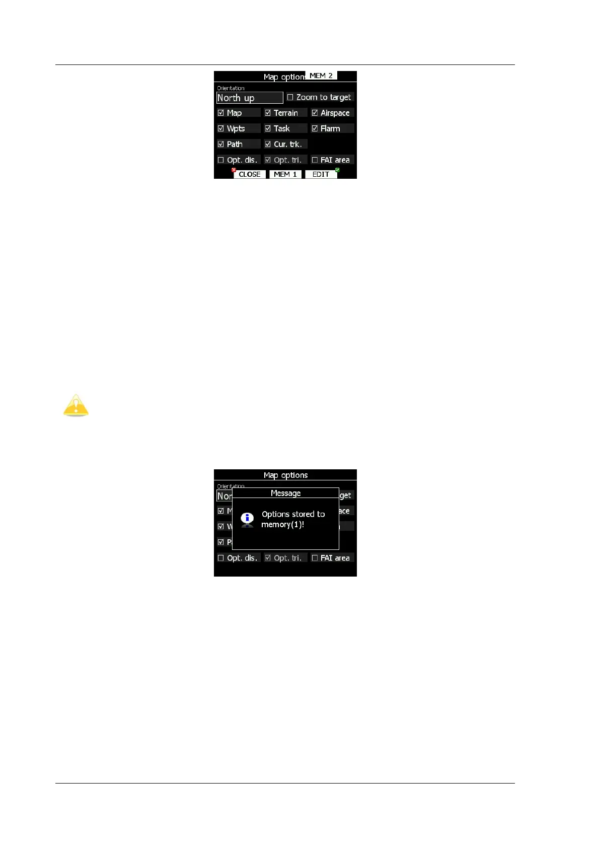
If Zoom to target check is selected, zoom will be automatically adjusted, so that target point
is always visible. Maximum zoom is 200km and minimum zoom is 1km. Next checkboxes will
turn on or off following items:
• Map – complete map is turned on/off
• Terrain – only terrain is turned on/off
• Airspace – toggle airspace display on/off
• Wpts – waypoints drawing is turned on/off
• Task – task drawing is turned on/off
• Flarm – Flarm radar display is turned on/off.
• Path – flown path is switched on/off
• Cur.trk – current track vector
• Opt.dis. – optimized distance
• Opt.tri. – optimized triangle
• FAI area – FAI triangle assistant is turned on/off
Flarm object may also be hidden, because competition mode is on or privacy
mode is on. Please check these settings, if FLARM objects are not visible, even if
item is checked.
It is possible to store map settings for future use. There are two memory locations MEM1
and MEM2 for two different memory settings.
Press button MEM 1 for long time. A message “Options stored to memory (1) will be
displayed and settings are stored. Change setting a little bit. Press button MEM2 for long
time. A message “Options stored to memory (2) will be displayed and settings are stored to
memory location 2. Now short pressing MEM1 will invoke saved settings under memory 1.
5.5.5.4 Wind
LX8000 constantly calculates winds using four different methods. Speed difference method is
used during circling and is taking into account ground speed difference in single circle.
Position drift is calculating wind based on position drift during circling. Minimum three circles
must be done to get first wind measurements. Third method is combination, which takes into
account also airspeed received from vario unit.
If compass module is available, wind is also estimated using wind triangle. Calculated wind is
stored in layers. Layer height is 300m or 1000ft and can not be modified by user.