Pilot's Operating Handbook
Section 2
Limitations
EASA Approved
Edition 0 - October 31, 2013
Rev. 6
Page 2.6.5
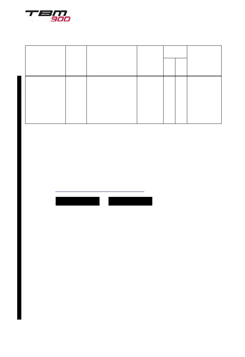
Phase of flight Notes
ICAO Flight
Plan Code
Reference
Documents
Operational limitations
Approved
PBN
Capability
Phase of flight Notes
Item
18
PBN/
Item
10a
Code
Reference
Documents
Operational limitations
Approved
PBN
Capability
Approach RNP
APCH
LPV
minima
(with and
without
RF legs)
At a minimum, the flight
director must be displayed
and utilized when
conducting procedures
containing RF legs.
EASA
AMC 20-28
B RF legs may be
used in the initial
and intermediate
legs of the
approach pro-
cedure or the
final leg of the
missed approach
procedure only.
1
and
2
, see Note 1 and Note 2 hereafter
Table 2.6.1 - GNSS operational requirements
Note 1 FDE/RAIM availability worldwide can be determined using the WFDE Prediction
program, part number 006-A0154--01 or later approved version with GARMIN GA36
and GA37 antennas selected, or :
- Within the United States, using the FAA's en--route and terminal RAIM prediction
website : www.raimprediction.net, or by contacting a Flight Service Station.
- Within Europe, using Europe's AUGUR GPS RAIM Prediction Tool at
http://augur.ecacnav.com/augur/app/home.
Note 2 A
BOTH ON GPS1
or
BOTH ON GPS2
system annunciation does not
necessarily mean that one GPS has failed. Refer to the MFD – GPS STATUS page
to determine the state of the unused GPS.
General considerations
The route planning and WFDE prediction program may be downloaded from the
GARMIN website on the internet. For information on using the WFDE Prediction
Program, refer to GARMIN WAAS FDE Prediction Program, part
number 190--00643--01, `WFDE Prediction Program Instructions'.
Garmin International holds an FAA Type 2 Letter of Acceptance (LOA) in accordance
with RTCA/DO-200A and AC 20-153B for database integrity, quality, and database
management processes for many of its aviation databases. LOA status and
RTCA/DO-200A List of Applicable Avionics (190-01999-00) can be viewed at
FlyGarmin.com.
Navigation information is referenced to WGS-84 reference system, and should only
be used where the Aeronautical Information Publication (including electronic data and
aeronautical charts) conform to WGS-84 or equivalent.