Do you have a question about the JRC JLR-7700MKII and is the answer not in the manual?
Explains safety and operational graphical symbols used in the manual.
Instructions that can cause death or severe injury if not observed.
Instructions that can cause injury or property damage if not observed.
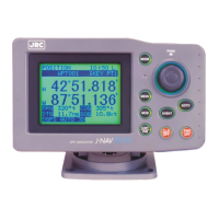
Shows the physical appearance of the DGPS Receiver and Navigator units.
Defines important terms used throughout the instruction manual.
Describes the functions, features, and overall capabilities of the JLR-7700 MKII.
Details equipment configuration, optional units, and the general system diagram.
Provides outline drawings and dimensions for the navigator and DGPS receiver.
Details the keys and their functions on the navigator's operation panel.
Identifies and describes the connectors and ports on the rear panel.
Details the components and functions of the DGPS receiver.
Guides the user through selecting the optimal location for DGPS receiver installation.
Provides step-by-step instructions for installing the DGPS receiver.
Details the process of mounting the DGPS receiver onto a mast.
Guides the user on choosing the best location for installing the navigator unit.
Provides instructions for securely mounting the navigator unit.
Explains how to mount the junction box onto a mast or flat surface.
Guides the user through connecting the navigator to power and grounding.
Details how to connect the DGPS receiver to the navigator for data transfer.
Describes data output formats and connections for external equipment.
Explains how to configure the relay output for external buzzer or log pulse.
Details how to connect cables to the junction box terminals and gasket selection.
Provides instructions for connecting waterproof connectors and optional data cables.
Provides guidelines to avoid electromagnetic interference during installation.
Guides the connection of optional units like buffer, AC power supply, and printer.
Covers fundamental operations like powering the unit on/off and language selection.
Introduces the different screens available on the navigator for operation.
Explains how to use the NAVIGATE, COURSE DEVIATION IND., and NAVIGATE AUX screens.
Details the NAVIGATE screen layout and how to set/manage destinations and routes.
Describes the COURSE DEVIATION IND. screen for course and steering guidance.
Covers magnetic compass correction, display unit, and data output format settings.
Details the PLOT screen for displaying tracked lines and managing plot intervals.
Covers settings for the geodetic system and DGPS beacon reception.
Explains how to register waypoints using the WAYPOINT screen.
Describes how to copy and erase waypoint data from the list.
Explains how to set, cancel, and manage route plans using waypoints.
Guides setting arrival, off-course, anchor, and boundary alarms.
Displays satellite status and guides initial system setup.
Covers averaging, HDOP levels, and antenna modes for position fixing.
Provides local weather and sea conditions for coastal Japan.
Explains how to display and set Loran time differences, including Loran A stations.
Details daily and periodic inspections to ensure proper equipment operation.
Advises on suitable environments to prevent equipment failure or reduced life.
Information on warranty repairs, post-warranty service, and required details for support.
Instructions for safely disposing of the equipment and its lithium battery.
Lists general functions, display, memory, power supply, and navigation calculations.
Details GPS receiving frequency, sensitivity, dynamic range, and accuracy.
Covers beacon receiving, operating temperature, waterproof, and EMC standards.
Provides outline drawings and specifications for optional units.
Lists error messages and navigation alarms with their descriptions and causes.
Provides a list of geodetic systems displayed on the screen and their corresponding systems.
Details NMEA0183 output sentences, timing, serial format, and data formats.
A blank table for recording waypoint information, including number, name, and remarks.
Lists main offices, plants, subsidiaries, branch, liaison, and service offices worldwide.
| Type | GPS Receiver |
|---|---|
| Channels | 12 channels |
| Update Rate | 1 second |
| Operating Temperature | -15°C to +55°C |
| Frequency | 1575.42 MHz (L1 band) |
| Accuracy | 10 meters |
| Display | LCD |