Do you have a question about the Teletype WorldNav and is the answer not in the manual?
Provides an overview of the software and its purpose.
Outlines user responsibilities and limitations for safe operation.
Congratulates the user and explains what the manual covers.
Guides users through initial setup and basic operations.
Defines key terms used within the software and manual.
Provides step-by-step instructions for initial setup and basic navigation.
Explains how to customize settings and transfer saved points.
Details the functions and layout of the main menu screens.
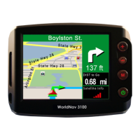
Explains the process of navigating from current location to a destination.
Describes how to switch between navigation and map browsing modes.
Guides on setting a home address and creating routes to specific destinations.
Details methods for locating and navigating to any address using the device.
Explains how to create routes to street intersections without exact addresses.
Covers finding and routing to Points of Interest like truck stops and restaurants.
Describes how to locate previously saved "My Points" for navigation.
Allows searching for services along the current travel route.
Explains how to access and manage past search history.
Provides instructions on avoiding route segments or clearing routes.
Covers configuration of GPS status and related settings.
Introduces features for managing saved locations and favorite places.
Guides on how to save a specific location as a "My Point".
Explains how to save the current GPS location as a "My Point".
Details how to manually enter coordinates to create a "My Point".
Covers editing, showing, routing to, or deleting existing "My Points".
Explains how to create routes with multiple stops or via specific points.
Introduces settings related to route calculation and truck-specific preferences.
Guides on choosing routing methods and truck settings for optimal trips.
Details how to select between Metric and English units for measurements.
Explains how to customize the information displayed on the navigation screen panels.
Allows users to choose which types of services appear on the map during travel.
Covers selecting voice prompts, keyboard layouts, and available languages.
Provides steps to adjust the device's time setting.
Introduces advanced features and customization options for the GPS device.
Guides on personalizing map display, zoom, themes, and cursors.
Allows adjustment of screen settings for optimal visibility in day or night conditions.
Reviews trip statistics like speed, distance, and estimated arrival time.
Explains how to load previously saved routes or save the current route.
Displays current location details and information about restricted road areas.
Allows users to preview a created route as if they were driving.
Addresses common issues and provides solutions for using the GPS device.