64
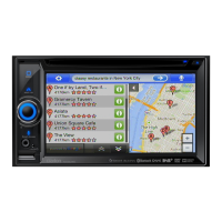
You have the following data and functions on this screen:
Name Description Function
or
Shows whether the route data fields show
information about the final destination (checkered
flag) or about the next via point (yellow flag) .
Field next to the flag Shows the name or number of the current street
or road.
Turn Preview Shows the type and distance of the next route
event.
Compass Shows the current heading. Tap this field to show it on the
map screen in one of the Trip
Data fields.
Speedometer Shows the current speed both graphically and as
a number.
Tap this field to show it on the
map screen in one of the Trip
Data fields.
Distance Remaining Shows the distance you need to travel on the
route before reaching your final destination.
Tap this field to show it on the
map screen in one of the Trip
Data fields.
Time Remaining Shows the time needed to reach the final
destination of the route based on information
available for the remaining segments of the route.
The calculation cannot take into account traffic
jams and other possible delays.
Tap this field to show it on the
map screen in one of the Trip
Data fields.
Arrival Time Shows the estimated arrival time at the final
destination of the route based on information
available for the remaining segments of the route.
The calculation cannot take into account traffic
jams and other possible delays.
Tap this field to show it on the
map screen in one of the Trip
Data fields.
GPS Time Shows the current time corrected with time zone
offset. The accurate time comes from the GPS
satellites, and the time zone information comes
from the map or it can be set manually in
Regional settings.
Tap this field to show it on the
map screen in one of the Trip
Data fields.
Altitude
Shows the elevation if it is provided by the GPS
receiver.
Tap this field to show it on the
map screen in one of the Trip
Data fields.
Speed Limit
Shows the speed limit of the current road if the
map contains it.
Tap this field to show it on the
map screen in one of the Trip
Data fields.
Opens a new screen with three
resettable Trip Computers.
Tap this button to change the
content of the Route Data fields
to show information about the
next via point.
 Loading...