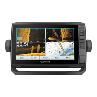
Navigation with a Chartplotter........ 30
Basic Navigation Questions................. 31
Route Color Coding............................... 31
Destinations.......................................... 32
Searching for a Destination by
Name.................................................. 32
Selecting a Destination Using the
Navigation Chart................................32
Searching for a Marine Services
Destination.........................................32
Setting and Following a Direct Course
Using Go To....................................... 32
Stopping Navigation..........................32
Waypoints.............................................. 33
Marking Your Present Location as a
Waypoint............................................ 33
Creating a Waypoint at a Different
Location............................................. 33
Marking an MOB Location................ 33
Projecting a Waypoint....................... 33
Viewing a List of all Waypoints........ 33
Editing a Saved Waypoint................. 33
Moving a Saved Waypoint................ 34
Browsing for and Navigating to a
Saved Waypoint................................. 34
Deleting a Waypoint or an MOB........34
Deleting All Waypoints...................... 34
Routes.................................................... 35
Creating and Navigating a Route From
Your Present Location...................... 35
Creating and Saving a Route............ 35
Viewing a List of Routes................... 35
Editing a Saved Route....................... 35
Browsing for and Navigating a Saved
Route.................................................. 36
Browsing for and Navigating Parallel
to a Saved Route............................... 36
Deleting a Saved Route..................... 36
Deleting All Saved Routes................. 36
Auto Guidance....................................... 37
Setting and Following an Auto
Guidance Path................................... 37
Creating and Saving an Auto Guidance
Path.................................................... 37
Adjusting an Auto Guidance Path.... 37
Canceling an Auto Guidance
Calculation in Progress..................... 38
Setting a Timed Arrival......................38
Auto Guidance Path
Configurations................................... 38
Tracks.................................................... 39
Showing Tracks................................. 39
Setting the Color of the Active
Track.................................................. 39
Saving the Active Track.................... 40
Viewing a List of Saved Tracks........ 40
Editing a Saved Track....................... 40
Saving a Track as a Route................ 40
Browsing for and Navigating a
Recorded Track................................. 40
Deleting a Saved Track..................... 40
Deleting All Saved Tracks................. 40
Retracing the Active Track................41
Clearing the Active Track.................. 41
Managing the Track Log Memory
During Recording............................... 41
Configuring the Recording Interval of
the Track Log..................................... 41
Boundaries.............................................41
Creating a Boundary..........................41
Converting a Route to a Boundary... 42
Converting a Track to a Boundary.... 42
Editing a Boundary............................ 42
Setting a Boundary Alarm................. 42
Deleting a Boundary.......................... 42
Deleting All Saved Waypoints, Tracks,
Routes, and Boundaries........................ 42
Sailing Features..............................42
Setting the Vessel Type for Sailing
Features................................................. 42
Sail Racing............................................. 43
Starting Line Guidance...................... 43
Using the Race Timer........................ 43
Setting the Distance between the Bow
and the GPS Antenna........................ 43
Laylines Settings................................... 44
Setting the Keel Offset.......................... 45
Sailboat Autopilot Operation................ 45
Wind Hold.......................................... 46
Tack and Gybe................................... 46
Heading Line and Angle Markers......... 47
Setting the Heading Line and Angle
Markers.............................................. 47
Viewing Sailing Vessel Data................. 47
ii Table of Contents