Do you have a question about the Lowrance GlobalMap 5000C and is the answer not in the manual?
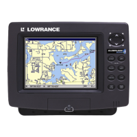
| Display Size | 5 inches |
|---|---|
| Display Type | Color TFT |
| Display Resolution | 480 x 480 pixels |
| Waterproof Rating | IPX7 |
| Weight | 2.2 lbs (1 kg) |
| Waypoints/Routes | 3000 waypoints, 100 routes |
| Chart Compatibility | Navionics |
| Memory | MMC card slot |
| Power Supply | 10-17 VDC |
Instructions for mounting the external GPS antenna and receiver module for optimal signal reception.
Guidance on connecting the GPS unit to a 12-volt battery system for power supply.
Instructions for physically mounting the GlobalMap unit using its bracket or for in-dash installation.
Steps to find and display the unit's current geographical location on the map.
Explains how to search for various map features, addresses, and points of interest.
Instructions for creating and saving waypoints at current position or specific locations.
Steps to set a destination and navigate to a previously saved waypoint.
How to activate the Man Overboard feature to mark a location quickly.
Guidance on navigating back to the Man Overboard position.
Navigating to a location selected directly on the map using the cursor.
How to find and navigate to Points of Interest (POI) using search functions.
Process for creating, recording, and saving travel paths (trails).
Methods for following a recorded trail, including visual trailing and navigation.
Steps to follow a saved trail in its original recorded direction.
How to follow a saved trail in reverse, from end to start.
Information on creating, saving, and navigating routes composed of waypoints.
Instructions for following a saved route from start to finish.
How to follow a saved route from the last waypoint back to the first.
Configuring various audible and visual alarms like arrival, off-course, and anchor alarms.
Using the unit in a simulated environment for practice and training.
Restoring all unit features to their factory default settings.
Managing trail recording settings, including update criteria and display visibility.
Locating specific street addresses by entering address number, street, and city.
Searching for Points of Interest (POI) by name or proximity.
Locating specific streets or street intersections by name.