Do you have a question about the AvMap EKP-IV and is the answer not in the manual?
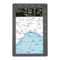
Describes the EKP-IV's capabilities and integration of GPS with moving maps for navigation.
Details main characteristics, flight plans, tracking, cartographic functions, and POI settings.
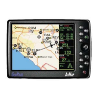
Explains basic operation, keyboard layout, and the function of the POWER key.
Provides a brief overview of key EKP-IV features like Main Menu, Moving Map, and GoTo.
Details the function and operation of the EKP-IV's 10 keys.
Provides instructions for powering the EKP-IV on and off, including countdown timers.
Explains how to adjust display brightness and contrast using the POWER key.
Guides on changing the display language for menus and options.
Covers connecting to external GPS sources and NMEA outputs.
Guides on accessing System Setup Menu for primary information display settings.
Explains how to input and edit data for waypoints, flight plans, and calculator functions.
Details the different operating modes of the Moving Map display: Cursor, Home, and Auto Zoom.
Describes the Data Window for user-defined navigation information and its customization.
Explains how Automatic Info provides details on cartographic objects when the cursor is over them.
Details sub-menus for cursor and position data, including airspace and full information.
Accesses setup functions for the Moving Map display, including orientation and zoom.
Shows data based on current flight plan leg or active waypoint, including CDI and airplane icon.
Allows saving the current GPS position as a user waypoint in the User Waypoint Database.
Explains how HSI calculates and displays flight parameters like heading, VSI, and CDI.
Accesses HSI menu options including setting data fields and compass orientation.
Displays information for the currently selected "Viewed" Flight Plan.
Guides on creating flight plans by selecting waypoints from the database.
Explains how to activate a flight plan for navigation and how to deactivate it.
Allows creating a user-defined name of up to 12 alphanumeric characters for each flight plan.
Deletes a flight plan from memory to enable creation of a new one.
Automatically reverses the sequence of waypoints stored in a flight plan.
Explains activating direct flight plans to database objects or cursor positions.
Lists nearest database objects and allows activation of a route to a selected item.
Displays GPS data in graphic mode, showing satellite availability and status.
Lists technical specifications of the GPS receiver, including channels and start times.
Details how GPS satellites broadcast signals and receivers triangulate position, including accuracy.
Covers creating, saving, editing, and deleting user waypoints directly from the Moving Map.
Covers creating, editing, and deleting user waypoints via the User Database Menu.
Allows searching and displaying information stored in data cartridges.
Explains how to display and select airport approaches from the Moving Map screen.
Covers programming an approach at the destination end of a flight plan.
Explains selecting, changing, or removing approaches when using the GOTO function.
Details setting and using the countdown timer, which requires a GPS fix to start.
Explains how the elapsed time timer calculates time from zero when activated.
Tracks speed, flying time, and distance traveled, calculated based on GPS parameters.
Explains the VNAV function for preparing descent profiles and recommendations.
Describes how to compute winds aloft by comparing ground speed/track with indicated air speed/heading.
Details computing fuel consumption based on user entries and flight plan data.
Provides a checklist for the engine start procedure, detailing items to check.
Lists items for the ground check procedure, including brakes, props, and fuel pressure.
Outlines the pre-take-off checklist items such as instruments, fuel tanks, and transponder.
Details the landing checklist items including mixture, fuel tanks, and lights.
Explains simulating a straight flight path by setting speed and heading.
Describes simulating flight along an existing flight plan by selecting speed and route parameters.
Provides instructions for turning the simulator off and returning to normal operation.
Details enabling NMEA formatted position information output to external equipment.
Explains sending and receiving waypoints to/from the serial port.
Describes sending and receiving flight plans to/from the serial port.
Explains sending track data from the serial port.
Controls EKP-IV settings like beeper, scale format, language, and military frequency display.
Manages GPS data input and display, including fix source, differential correction, and symbols.
Configures alarm settings for arrival radius, XTE range, and airspace ahead warnings.
Manages track display, recording step, and clearing track history data.
Defines how the EKP-IV displays units of measurement for distance, speed, altitude, etc.
Controls EKP-IV time and date display settings, including format and local time difference.
Sets background colors for data windows and track display line colors.
Deletes all flight plans, track history, and user waypoints.
Deletes all stored Projected Radial lines displayed on the Moving Map.
Restores the EKP-IV to all factory default settings, clearing user data.
Explains how to assemble and place the GPS antenna for optimal signal reception.
Guides on securing the EKP-IV to the leg using the provided elastic strap.
Provides the physical dimensions of the EKP-IV unit.
Provides common problems and solutions for power, GPS fix, and device responsiveness.
Offers system tests like RAM Clear and C-CARD checks to resolve operational problems.