122
AutoChart Live
1. PREPARE THE CONTROL HEAD FOR MAPPING
W
hen you start your mapping for the day, it is important to note if the water level is higher or lower than usual. It is also important
t
o use your 2D transducer beams exclusively.
1
|
Set the Map Source
AutoChart LIVE can be used when Humminbird LakeMaster or Navionics is set as the map source. When you install a map card, the
map source is changed automatically to match the SD card map source. If your control head has two cards installed, you can choose
which map source you want to use. You can also change the map source using the Settings tool.
1. Press the HOME key.
2. Select Settings.
3. Select Chart.
4. Select Humminbird or Navionics.
2
|
Confirm the 2D Transducer and Turn off Additional Transducers
To record your custom map, you must have a reliable and accurate digital depth from a pinging 2D transducer. You can use your
Humminbird CHIRP transducer with 2D (down beam) capabilities, DualBeam PLUS transducer (83/200 kHz or 50/200 kHz), or the
Side Imaging tranducer with 2D (down beam) capabilities.
When you are recording your map, you should have only one 2D transducer pinging on your boat. If you have other 2D transducers
pinging on remote control heads, you should turn them off. Down Imaging and Side Imaging beams can operate at the same time.
You do not need to turn them off.
1. Press the HOME key.
2. Select Settings.
3. Select CHIRP Sonar.
4. Select Sonar Source.
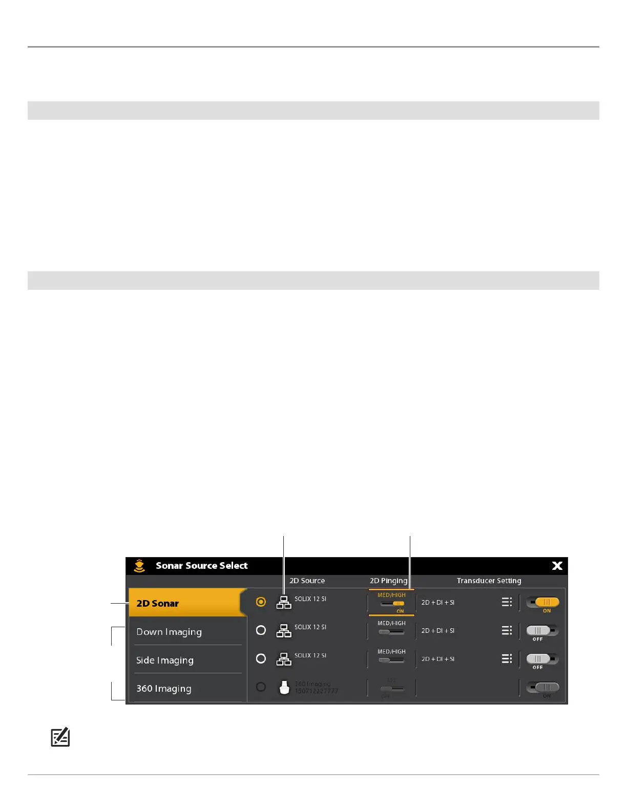
5. Select the 2D Sonar tab.
6. Confirm that 2D Pinging is turned on. Tap the 2D Pinging on/off button, or press the ENTER key, to turn it on.
NOTE: For more information about the Sonar Source Select dialog box, see Set up your Humminbird Network: Select Sonar
Sources.
transducer connection location
(connected to a remote SOLIX Control Head)
pinging turned on
2D sonar tab
selected
additional
sonar source
tabs
 Loading...