EasyManuals Logo

Humminbird SOLIX series User Manual

Humminbird SOLIX series
288 pages
To Next Page IconTo Next Page
To Previous Page IconTo Previous Page
Page #18 background imageLoading...
Page #18 background image
18
Getting Started
GPS (1) and GPS (2) Sources
You can also manually change which GPS receiver is the selected source for GPS (1) or GPS (2). To change the GPS sources, see
Set up your Humminbird Network.
GPS (1) provides position data, Speed over Ground (SOG), Course over Ground (COG), waypoints, routes, tracks, and navigation
calculations to the control head.
GPS (2) provides position data that is displayed in the GPS (2) data box.
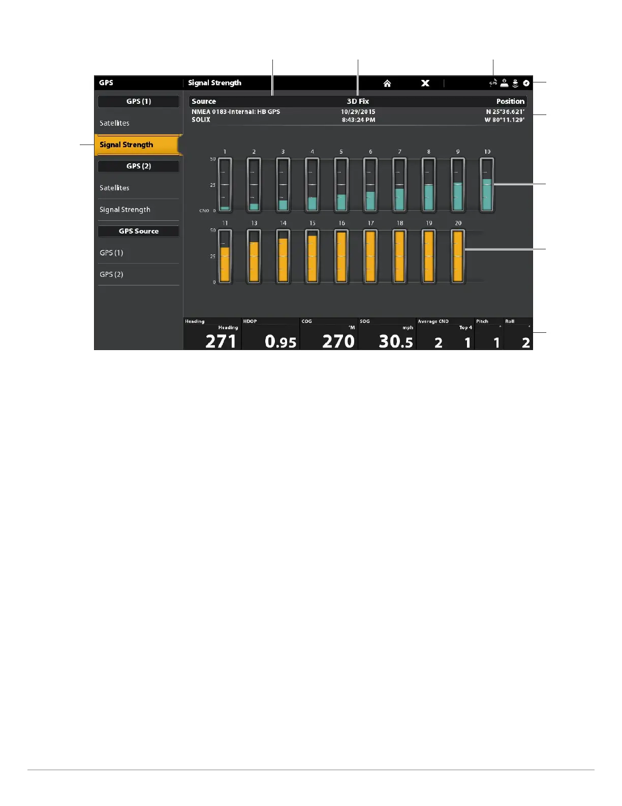
boat position
(latitude/
longitude)
status bar
GPS status icon
satellites
signal strength
GPS (1)
Signal Strength (bar graph)
selected GPS source
monitored
satellite
(teal) and
strength
level
used satellite
(yellow) and
strength
level
fix type
Signal Strength (GPS 1/GPS 2): displays vertical bar graphs indicating the satellite
signal strengths with the respecting CNO (Carrier-to-Noise) value (0 to 60).
digital
readouts

Table of Contents

Other manuals for Humminbird SOLIX series

Questions and Answers:

Question and Answer IconNeed help?

Do you have a question about the Humminbird SOLIX series and is the answer not in the manual?

Humminbird SOLIX series Specifications

General IconGeneral
Depth-Sonar StandardUp to 1, 500 feet (varies by model)
InterfaceTouchscreen
GPSYes
CartographyHumminbird Basemap
Target Separation2.5 inches
NetworkingEthernet, NMEA 2000
Memory Card SlotYes
WaterproofIPX7
Operating Frequency1.2MHz
DimensionsVaries by model
WeightVaries by model
Display Size10.1", 12.1"
Display Resolution1280 x 800 pixels (varies by model)
Operating Temperature-15°C to 55°C (5°F to 131°F)

Related product manuals