ORION® Mobile Read
Page 28 April 2019
Settings – ORION Devices:
Geocoding
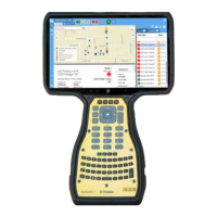
OMR software has the ability to geocode a Best Read location during route reading. This
feature allows the utility to maintain the established latitude and longitude of where the
meter is located while taking advantage of an independent best read location latitude and
longitude used for meter reading purposes.
This feature can also be a good solution for a utility that does not have the means to
establish a latitude and longitude in their billing software. Geocoding allows the utility to
take advantage of mapping features including missed meter notifications.
To activate the Geocoding feature, follow these steps.
1. Navigate to Configurations | ORION Devices
2. Tap to place a checkmark in the Calculate Best Read Location box
3. Tap Save
As the route is read, latitudes and longitudes of the best read locations become a part of
the ORION Mobile Read software. These latitude and longitudes do not pass to BEACON
therefore they do not interfere with established meter asset latitude and longitudes in the
BEACON database. The Best Read map icons will be ready to use and will display during
the next reading cycle.
Best Read icon or BEACON Service Address icon
At the start of the reading cycle, two icons could display on the Active tab to help identify
field assignments.
A blue diamond on the map is used to help guide the meter reader to the Best Read
location of an open field assignment.
Note: Before establishing a Best Read location, OMR will use the latitude and longitude
that is stored in the BEACON database, even if the icon displays in the center of the
customer’s property.
 Loading...
