Do you have a question about the Dynon SkyView Classic and is the answer not in the manual?
Details the Air Data Attitude and Heading Reference System module.
Details how to configure screen layouts and page allotments.
Covers charging procedures and testing of the backup battery.
Explains the use of airspeed, altitude, and heading bugs for autopilot control.
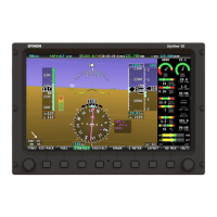
Details the PFD display elements for airspeed.
Explains how to set the airspeed bug on the PFD.
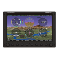
Describes the symbology of the attitude indicator display.
Explains the flight path marker icon and its meaning.
Details the PFD display elements for altitude and barometer setting.
Explains the altitude bug's use as an autopilot target for pitch axis.
Details the PFD display elements for vertical speed.
Explains the VS bug's use as an autopilot target for pitch axis.
Describes the display of magnetic heading, compass rose, and track pointer.
Explains how to set the heading or track bug for autopilot control.
Explains the Horizontal Situation Indicator presentation.
Details the primary sources for HSI data: GPS and NAV radio.
Explains how the CDI indicates deviation from the selected course.
Details the display of bearing pointers to radio stations or waypoints.
Describes the simulation of lateral acceleration for coordinated flight.
Details the display of Angle of Attack when probe is installed.
Explains the integrated Synthetic Vision feature on the PFD.
Explains how traffic information is displayed within Synthetic Vision.
Details the red arrows indicating extreme pitch attitudes.
Guide to selecting and configuring ADAHRS source pages.
Details how to select PRIMARY and ALTERNATE ADAHRS.
Toggles the G Meter display on/off and explains its features.
Cycles the HSI through different connected navigation data sources.
Details how to access and use the Weight and Balance calculator.
Guide to accessing and viewing the maintenance log.
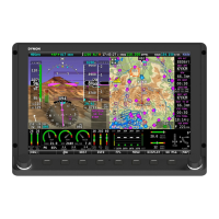
Describes the layout and configuration of the three Engine Pages.
Details the combined gauge for Cylinder Head and Exhaust Gas Temperatures.
Guides on setting engine mixture using EGT display and automated function.
Details fuel remaining, used, efficiency, and range calculations.
Guide to adjusting fuel computer settings and state.
Describes configuration for monitoring both engines with two EMS modules.
Details the features of the VP-X interface for SkyView control.
Explains the graphical representation of the aircraft's electrical system.
Explains transponder status elements shown in the Top Bar.
Details how to access and operate the transponder via the menu.
Details ADS-B output requirements and connectivity.
Details the methods for purchasing and installing the mapping software license.
Covers available databases like Terrain, Aviation, Obstacles, and Charts.
Explains databases for airports, nav aids, airspace, and obstacles.
Details support for US and European procedure charts and airport diagrams.
Guide to purchasing and preparing USB sticks for Seattle Avionics data.
Details on purchasing Seattle Avionics ChartData via their website.
Explains how SkyView determines and prioritizes GPS sources.
Describes the real-time topographical map display and its elements.
Details topography display and terrain proximity alerting.
Explains the aircraft icon and ground track line on the map.
Describes the distance circle and its relation to the aircraft icon.
Explains map elements related to ground track, heading, and course lines.
Explains how obstacles are represented on the Moving Map.
Details how different classes of airspace are represented on the Moving Map.
Describes the display of navaids like VORs, fixes, NDBs, and User Waypoints.
Explains the representation of NDBs and Outer Markers.
Describes how airports are represented on the map, including runway direction.
Guide to customizing map elements like airspace display.
Explains how traffic information is displayed on the Map Page.
Details traffic display capabilities of ADS-B modules.
Describes targets with a high chance of ending up near the aircraft.
Describes the yellow alert message for Traffic Advisory Targets.
Covers course information display and navigation methods.
Quickly lists nearest airports, navaids, and user waypoints.
Applies criteria to filter nearest airports, like surface type and name.
Guide to navigating directly to a selected waypoint.
Explains how to pan the map using the map pointer.
Guide to selecting map items using the map pointer.
Describes flight plans as sequences of waypoints and leg transitions.
Covers SkyView's VFR vertical navigation to airports or runways.
Explains HSI guidance for active flight plan legs.
Details sending/receiving flight plans between SkyView and ForeFlight Mobile.
Steps to set up Wi-Fi network for SkyView and ForeFlight connection.
Instructions for sending and receiving flight plans with ForeFlight app.
Explains how SkyView sends GPS position and flight data to ForeFlight.
Details sending/receiving flight plans between SkyView and PocketFMS EasyVFR.
Steps to set up Wi-Fi network for SkyView and PocketFMS connection.
Instructions for sending and receiving flight plans with PocketFMS.
Guide to adding waypoints to a flight plan.
Procedure to activate SkyView flight plan routing.
Allows setting and adjusting an inbound course to any navigable point.
Explains how to change the inbound course while in OBS Mode.
Details available procedure charts and airport diagrams.
Explains creating, manipulating, and importing/exporting User Waypoints.
Guide to creating a new waypoint at current location or map pointer.
Procedure to modify or delete existing user waypoints.
Guide to adjusting map preferences like weather options and map items.
Settings for incoming flight plans and ETA calculations.
Describes touch shortcuts for info items on the Moving Map.
Details FAA's ADS-B network for weather and TFR data transmission.
Explains routine weather reports updated hourly.
Explains how NEXRAD radar data is depicted graphically on the map.
Describes how FAA temporary flight restrictions are graphically depicted.
Instructions for displaying NEXRAD weather and TFRs on map layers.
Discusses circumstances where NEXRAD imagery may not be available.
Shows ADS-B receiver status and age of weather data.
Accesses weather reports via the WX tab in the INFO window.
Details failsafe features ensuring autopilot can be disabled.
Explains servo failsafe mechanisms for overriding autopilot commands.
Allows selection between Simplified and Expert Autopilot control schemes.
Enables automatic aircraft trimming while the Autopilot is engaged.
Covers autopilot usage with Simplified control schemes.
Summarizes autopilot modes for roll and pitch axes.
Covers autopilot usage when set to Expert controls.
Illustrates the Expert Autopilot Menu buttons and their functions.
Explains procedures for disengaging the autopilot and flight director.
Summarizes autopilot modes of operation for the roll axis.
Summarizes autopilot modes of operation for the pitch axis.
Visual indication on PFD showing aircraft movement for autopilot guidance.
Allows temporary manual adjustment of autopilot targets.
Procedure to track GPS or VOR navigation sources.
Steps for executing a precision approach with autopilot guidance.
Explains the Go Around function for missed approaches.
Explains how touching PFD items reassigns joystick knobs.
Describes SkyView's alert severity categories and notification types.
Details engine parameter alerts (High/Low) and specific warnings.
Explains the meaning and implications of a standby network error alert.
| Brand | Dynon |
|---|---|
| Model | SkyView Classic |
| Category | Avionics Display |
| Language | English |