2. OPERATION
2-8
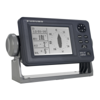
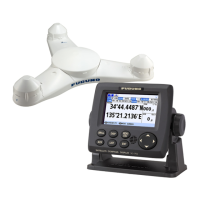
2.7.2 GPS integrity screen
The GPS integrity display shows satellite status and various integrity-related data, as
shown in the figure and table below.
No. Name Description
1 Satellite positions Shows the available satellites and their elevation.
• Light blue shaded circle: Indicates area where multipath
can be used.
• White numerals: Indicates satellites used for position fix.
• Own ship is shown at the center of the circle.
Press X to alternate between North-Up and Head-Up orien-
tations.
2 Own ship position/positioning
reference
Shows OS coordinates and positioning reference.
3 Text data box See section 2.7.1.
4 RX level Shows the strength of the signal received from the satellite
code.
• [SV PRN]: Satellite number.
• [SNR]: Signal to Noise Ratio.
When more than 10 satellites are in use, press S or T to
scroll though the list.
5 Satellite color codes Shows the color code for the satellites currently in use. The
displayed indications are abbreviated as follows:
• [GP]: GPS.
• [GL]: GLONASS.
• [GA]: Galileo
• [SBAS]: SBAS
GP-D3D
WGS84
34° 44. 4476'
135° 21. 2160'
1 . 3 4 / 100m
05 : 14 ' 47 21 / APR / 16
SAFE
31
26
16
29
14
27
21
3
129
137
26
16
31
29
14
21
3
137
27
 Loading...