Do you have a question about the TeeJet MATRIX 570G and is the answer not in the manual?
Lists the main features of the Matrix system, including RealView, BoomPilot, and FieldPilot.
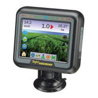
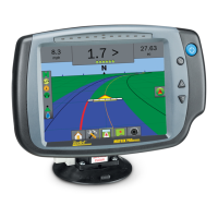
Details the physical components like consoles and cameras.
Provides operating instructions, navigation tips, and access to main functions.
Configures overlap, delay, boom sections, and width for BoomPilot.
Configures swath width when BoomPilot is not present.
Selects the vehicle steering type that best represents the user's vehicle.
Sets the height of the antenna from the ground.
Defines boom location relative to the GPS antenna.
Explains when calibration options are not available.
Turns tilt correction on/off and calibrates the gyro.
Indicates when FieldPilot system is not installed or available.
Sets FieldPilot to the on or off position.
Provides straight line guidance based on A and B reference points.
Provides guidance along curved lines based on an initial A-B reference.
Provides guidance around a central location, radiating inward or outward.
Informs of speed, swath number, navigation activity, and accumulated area.
Shows icons for FieldPilot, Guidance Mode, BoomPilot, and GPS status.
Details guidelines, points, and coverage area on the display.
Provides access to zoom and perspective adjustments.
Allows selection of guidance modes like Straight A-B, Curved A-B, etc.
Drives to desired locations to establish the A-B line for guidance.
Shifts the existing A-B guideline to the vehicle's current location.
Drives to desired locations to establish the A-B arc for guidance.
Shifts the existing A-B guideline to the vehicle's current location.
Guides the vehicle to apply the first pass next to the applied area.
Turns off all active guidance modes.
Clears all guidance points, lines, boundaries, and totals.
Clears current job information or saves it to a USB drive.
Backs up job and stores information to a USB drive.
Lists and describes icons for main menu options and unit setup configurations.
Lists and describes icons for system setup, GPS type, port, and status.
| GNSS Receiver | Yes |
|---|---|
| Power Supply | 12V DC |
| Mapping | Yes |
| Steering | Yes |
| Update Rate | 10 Hz |
| Storage Temperature | -30°C to 70°C |
| Waterproof Rating | IP67 |
| Display Type | Color LCD |
| GPS Accuracy | Sub-meter |
| Connectivity | Bluetooth, USB |
| Antenna | External |
| Operating Temperature | -20°C to 60°C |