Using the External Computer Data Link MicronNav System
0656-SOM-00001-07 119 © Tritech International Ltd.
7.2.7. NMEA $GPGGA
This NMEA string format is used for Global Positioning and mainly sent by GPS devices. It
is a common format for providing co-ordinate positions in Latitude / Longitude format. There
are a number of fields in this string that are not applicable and these fields have been set
to sensible values as default.
The full string format is as follows:
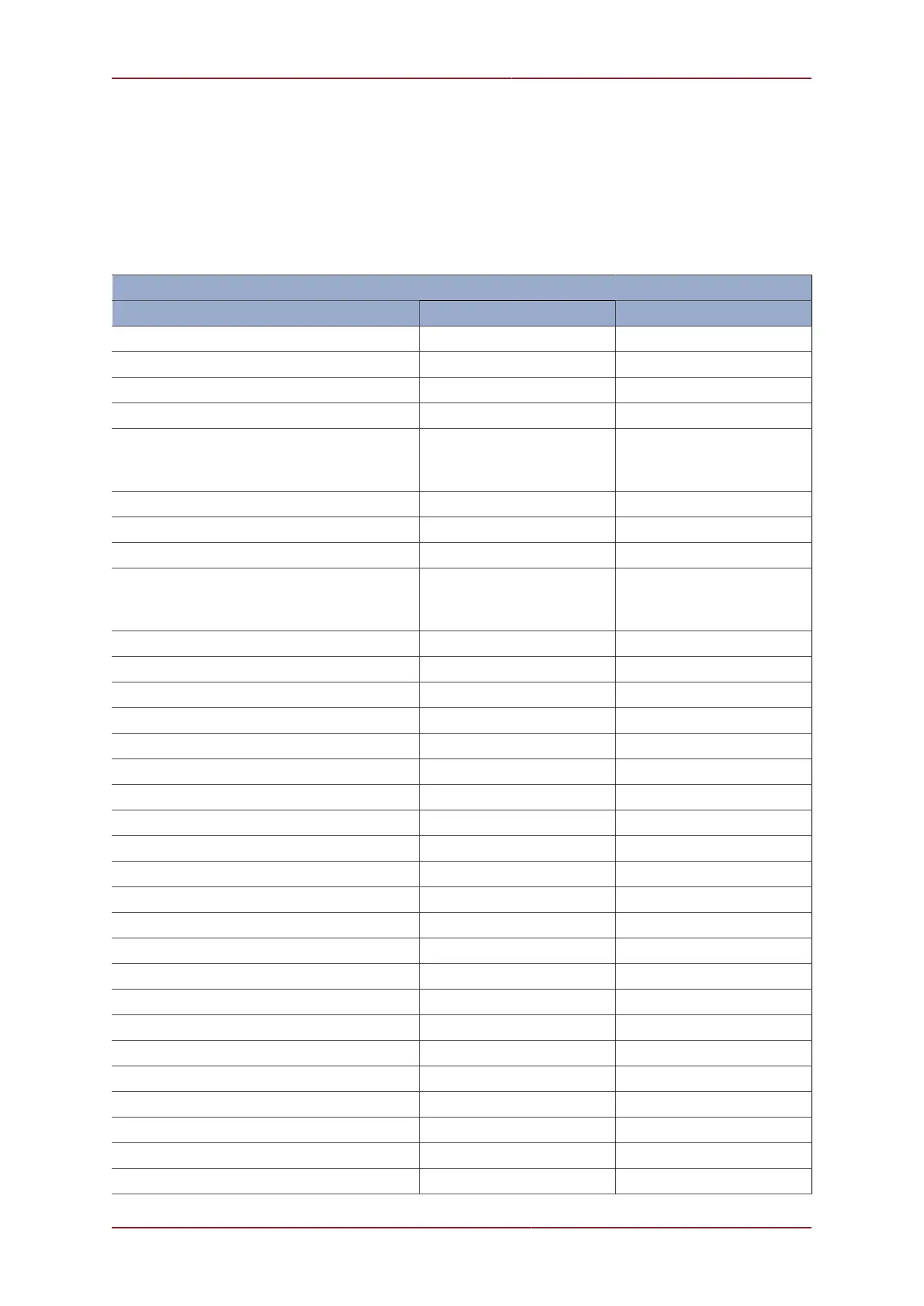
‘$GPGGA’ Reply Data Structure
Data Description Data Range Field Range
NMEA string header Always ‘$GPGGA’ hhhhhh
Comma separator Always ‘,’ ,
Time of data, UTC = hhmmss.ss 000000.00 to 235959.99 hhmmss.ss
Comma separator Always ‘,’ ,
Latitude of Target in Deg Min
(Only valid when Compass and GPS input
data are valid)
0 to 90 Degs DDMM.SSSS
Comma separator Always ‘,’ ,
Latitude N or S ‘N’ or ‘S’ a
Comma separator Always ‘,’ ,
Longitude of Target in Deg Min
(Only valid when Compass and GPS input
data are valid)
0 to 180 Degs DDDMM.SSSS
Comma separator Always ‘,’ ,
Longitude E or W ‘E’ or ‘W’ a
Comma separator Always ‘,’ ,
GPS Quality Indicator Always 2 (DGPS) x
Comma separator Always ‘,’ ,
Number of Satellites in Use Always 7 (N/A) xx
Comma separator Always ‘,’ ,
HDOP Always 2.2 x.x
Comma separator Always ‘,’ ,
Antenna Altitude Always 0.0 x.x
Comma separator Always ‘,’ ,
Altitude Units Identifier ‘M’ for metres a
Comma separator Always ‘,’ ,
Geoidal Separation Always 0.0 x.x
Comma separator Always ‘,’ ,
Units Identifier ‘M’ for metres a
Comma separator Always ‘,’ ,
Age of Differential GPS data Always 1.2 x.x
Comma separator Always ‘,’ ,
Differential Reference Station ID Always 1234 xxxx
Comma separator Always ‘,’ ,
Delimiter (asterisk) Always ‘*’ *