Using the External Computer Data Link MicronNav System
0656-SOM-00001-07 121 © Tritech International Ltd.
7.2.8. NMEA $GPGLL
This NMEA string format is used for Global Positioning and mainly sent by GPS devices. It
is a common format for providing co-ordinate positions in Latitude / Longitude format.
The full string format is as follows:
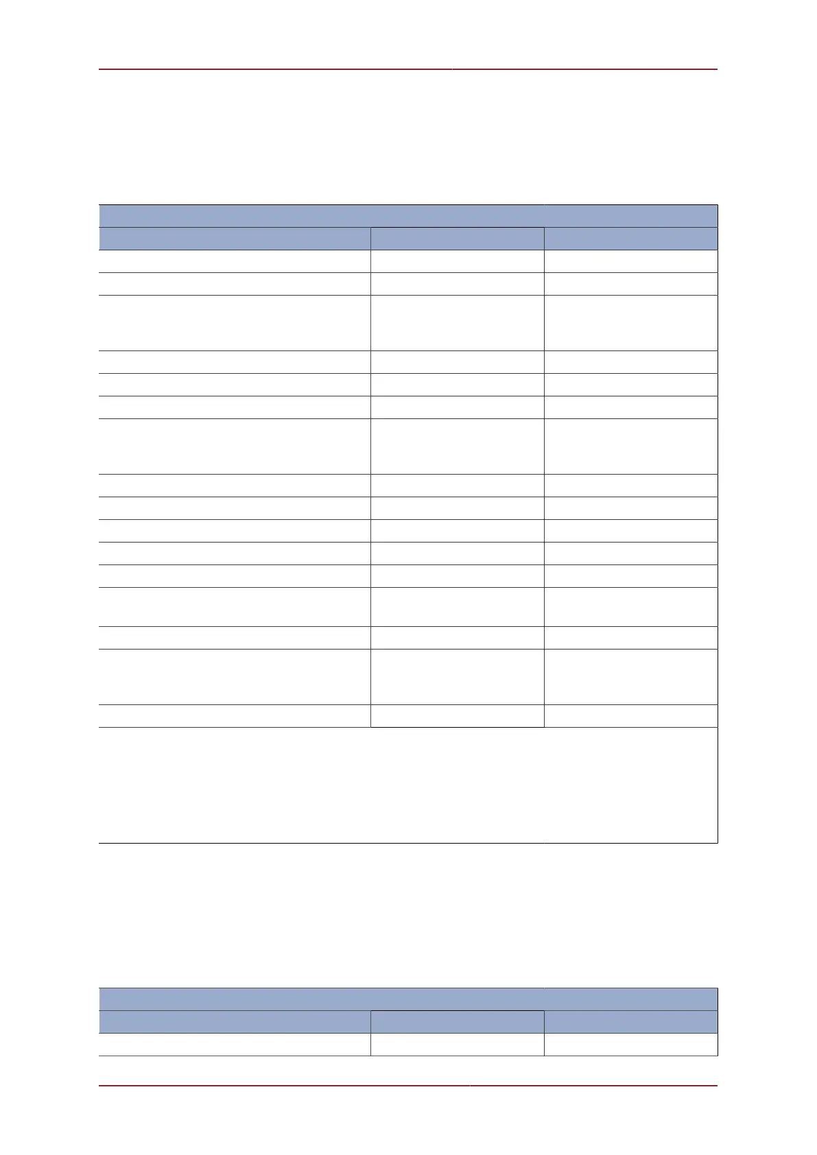
‘$GPGLL’ Reply Data Structure
Data Description Data Range Field Range
NMEA string header Always ‘$GPGLL’ hhhhhh
Comma separator Always ‘,’ ,
Latitude of Target in Deg Min
(Only valid when Compass and GPS input
data are valid)
0 to 90 Degs DDMM.SSSS
Comma separator Always ‘,’ ,
Latitude N or S ‘N’ or ‘S’ a
Comma separator Always ‘,’ ,
Longitude of Target in Deg Min
(Only valid when Compass and GPS input
data are valid)
0 to 180 Degs DDDMM.SSSS
Comma separator Always ‘,’ ,
Longitude E or W ‘E’ or ‘W’ a
Comma separator Always ‘,’ ,
Time of data, UTC = hhmmss.ss 000000.00 to 235959.99 hhmmss.ss
Comma separator Always ‘,’ ,
Fix Status (invalid if Ping not okay or no
valid attitude or compass data)
‘A’ = Valid, ‘V’ = Invalid x
Delimiter (asterisk) Always ‘*’ *
Checksum (in Hexadecimal)
(XOR of bytes between, but not inclusive
of, '$' and '*')
00 to FF cc
(Carriage Return + Line Feed) N/A <CR><LF>
Example:
Target Latitude = 54º 22’ 22.21” (N), Target Longitude = 2º 56’ 23.91” (W), UTC Time of reading =
143231.51.
ASCII Output Always = “$GPGLL,5422.3701,N,00256.3986,W,143231.51,A*54<CR><LF>”
Where; “<CR>” is Carriage Return (ASCII code 13), “<LF>” is Line Feed (ASCII code 10).
7.2.9. NMEA $GPRMC
This NMEA string format is used for Global Positioning and mainly sent by GPS devices. It
is a common format for providing co-ordinate positions in Latitude / Longitude format.
The full string format is as follows:
‘$GPRMC’ Reply Data Structure
Data Description Data Range Field Range
NMEA string header Always ‘$GPRMC’ hhhhhh