ItemDescription
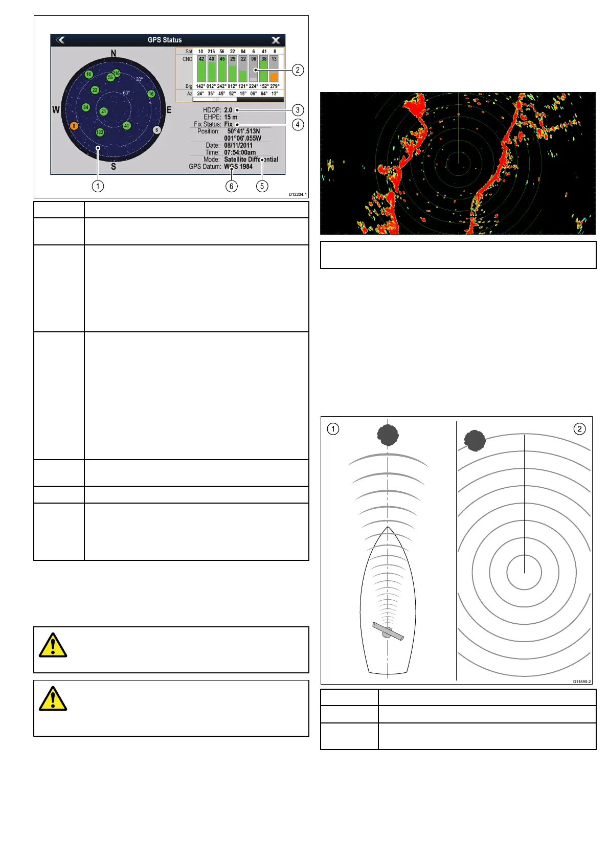
1
Skyview—avisualrepresentationofthepositionoftracked
satellites.
2
Satellitestatus—displaysthesignalstrengthandstatusof
eachsatelliteidentiedintheskyviewdiagramontheleftofthe
screen.Thecoloredbarshavethefollowingmeanings:
•Grey=searchingforsatellite.
•Green=satelliteinuse.
•Orange=trackingsatellite.
3
HorizontalDilutionofPosition(HDOP)—ameasureof
GPSaccuracy,calculatedfromanumberoffactorsincluding
satellitegeometry,systemerrorsinthedatatransmissionand
systemerrorsintheGPSreceiver.Ahigherguresigniesa
greaterpositionalerror.AtypicalGPSreceiverhasanaccuracy
ofbetween5and15m.Asanexample,assumingaGPS
receivererrorof5m,anHDOPof2wouldrepresentanerror
ofapproximately15m.Pleaserememberthatevenavery
lowHDOPgureisNOguaranteethatyourGPSreceiveris
providinganaccurateposition.Ifindoubt,checkthedisplayed
vesselpositioninthechartapplicationagainstyouractual
proximitytoaknownchartedobject.
4
Fixstatus—indicatestheactualmodetheGPSreceiveris
reporting(NoFix,Fix,DFixorSDFix).
5
Mode—themodecurrentlyselectedbytheGPSreceiver.
6
Datum—TheGPSreceiver’sdatumsettingaffectsthe
accuracyofthevesselpositioninformationdisplayedinthechart
application.InorderforyourGPSreceiverandmultifunction
displaytocorrelateaccuratelywithyourpapercharts,theymust
beusingthesamedatum.
TheaccuracyoftheGPSreceiverdependsontheparameters
detailedabove,especiallytheazimuthandelevationangleswhich
areusedintriangulationtocalculateyourposition.
Radarcheck
Warning:Radarscannersafety
Beforerotatingtheradarscanner,ensureallpersonnel
areclear.
Warning:Radartransmissionsafety
Theradarscannertransmitselectromagneticenergy.
Ensureallpersonnelareclearofthescannerwhen
theradaristransmitting.
Checkingtheradar
1.SelecttheRadarapplication.
TheRadarscannerwillnowinitializeinstandbymode.This
processwilltakeapproximately70seconds.
2.PresstheMENUbutton.
3.SelectPower.
4.SelecttheOnoption.
5.SelectRadar.
6.SelecttheTransmitoption.
Theradarscannershouldnowbetransmittingandreceiving.
7.Checkthattheradarscreenisoperatingcorrectly.
TypicalHDdigitalradarscreen
Note:Theexampleaboveisrepresentativeoftheenhanced
outputprovidedbyaHDdigitalradarscanner.
Pointstocheck:
•Radarsweepwithechoresponsesareshownonscreen.
•Radarstatusiconrotatingintoprighthandcorner.
Checkandadjustbearingalignment
Bearingalignment
Theradarbearingalignmentensuresthatradarobjectsappearat
thecorrectbearingrelativetoyourboat’sbow.Youshouldcheck
thebearingalignmentforanynewinstallation.
Examplemisalignedradar
ItemDescription
1
Targetobject(suchasabuoy)deadahead.
2Targetdisplayedontheradardisplayisnotalignedwiththe
Ship’sHeadingMarker(SHM).Bearingalignmentisrequired.
Checkingthebearingalignment
1.Withyourvesselunderway:Alignthebowwithastationary
objectidentiedontheradardisplayAnobjectbetween1&2
NMdistantisideal.
2.Notethepositionoftheobjectontheradardisplay.Ifthetarget
isnotundertheshipsheadingmarker(SHM),thereisan
Gettingstarted
63
 Loading...


