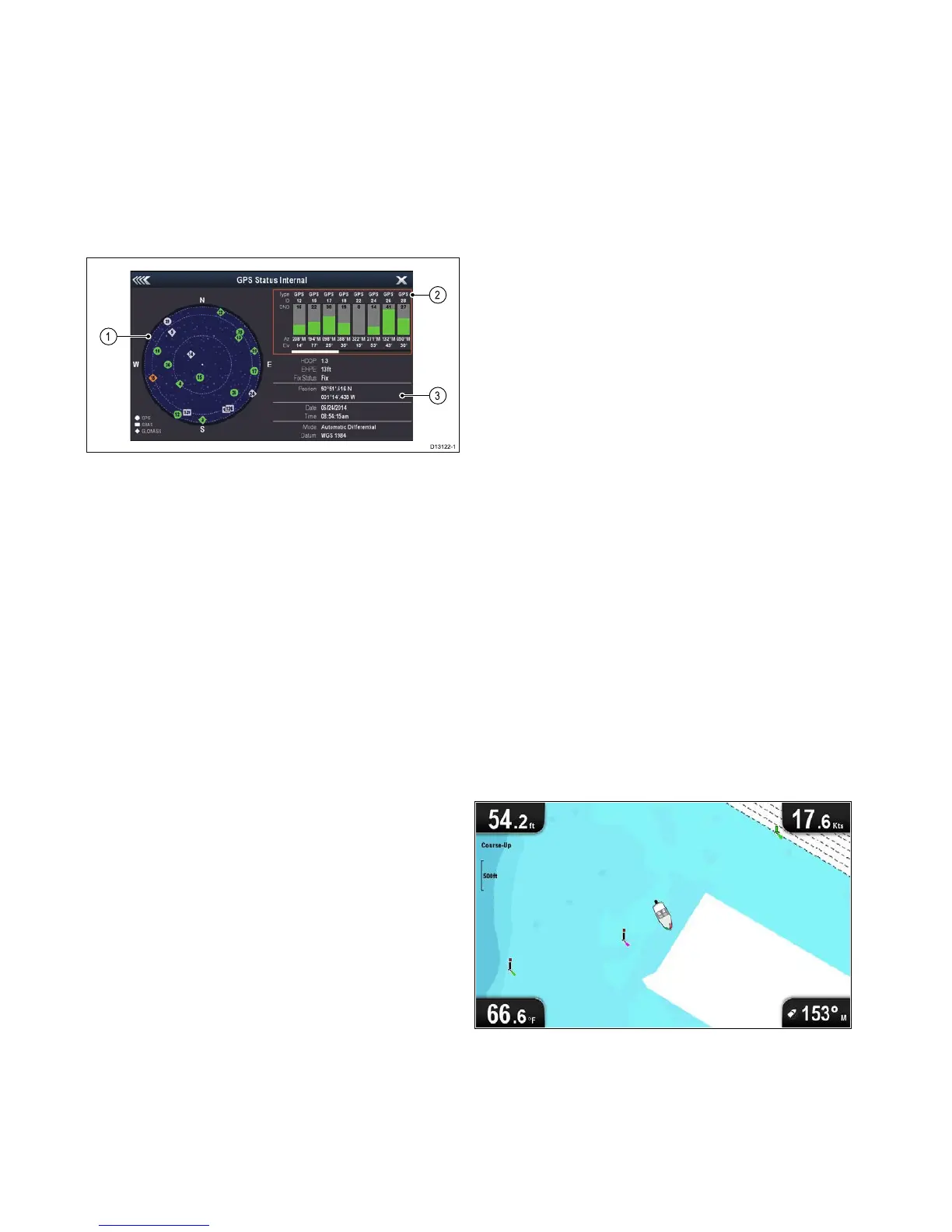
1.Skyview
2.Satellitestatus
3.Positionandxinformation
Skyview
Skyviewisavisualrepresentationthatshows
thepositionofnavigationsatellitesandtheirtype.
Satellitetypesare:
•Circle—Acircleidentiesasatellitefromthe
GPSconstellation.
•Square—Asquareidentiesan(SBAS)
differentialsatellite.
•Diamond—Adiamondidentiesasatellitefrom
theGLONASSconstellation.
Satellitestatusarea
TheSatellitestatusareadisplaysthefollowing
informationabouteachsatellite:
•Type—Identieswhichconstellationthesatellite
belongsto.
•ID—Displaysthesatellitesidenticationnumber.
•CNO(Carrier-to-noiseratio)—Displaysthesignal
strengthofeachsatelliteshownintheSkyview:
–Grey=searchingforsatellite
–Green=satelliteinuse
–Orange=trackingsatellite
•AzimuthandElevation—Providestheangleof
elevationandazimuthbetweenthelocationofthe
receiverandthesatellite.
Positionandxinformation
Thefollowingpositionalandxinformationis
provided:
•HorizontalDilutionofPrecision(HDOP)
—HDOPisameasureofsatellitenavigation
accuracy,calculatedfromanumberoffactors
includingsatellitegeometry,systemerrorsin
thedatatransmissionandsystemerrorsinthe
receiver.Ahigherguresigniesagreater
positionalerror.Atypicalreceiverhasanaccuracy
ofbetween5and15m.Asanexample,assuming
areceivererrorof5m,anHDOPof2would
representanerrorofapproximately15m.Please
rememberthatevenaverylowHDOPgureis
NOguaranteethatyourreceiverisprovidingan
accurateposition.Ifindoubt,checkthedisplayed
vesselpositionintheChartapplicationagainst
youractualproximitytoaknownchartedobject.
•EstimatedHorizontalPositionError(EHPE)
—EHPEisameasureoftheestimatederrorof
apositionxinthehorizontalplane.Thevalue
displayedindicatesthatyourpositioniswithina
circleradiusofthestatedsize50%ofthetime.
•Fixstatus—indicatestheactualmodethe
receiverisreporting:
–Fix—Satellitexhasbeenacquired.
–NoFix—Nosatellitexcanbeacquired.
–DFix—Adifferentialbeaconxhasbeen
acquired.
–SDFix—Adifferentialsatellitexhasbeen
acquired.
•Position—Displaysthelatitudeandlongitude
positionofyourreceiver.
•Date/Time—Displaysthecurrentdateandtime
generatedbythepositionxinUTCformat.
•Mode—Identieswetherthereceiverisworking
indifferentialmodeornon-differentialmode.
•Datum—Thereceiver'sdatumsettingaffects
theaccuracyofthevesselpositioninformation
displayedintheChartapplication.Inorderforyour
receiverandMFDtocorrelateaccuratelywithyour
papercharts,theymustbeusingthesamedatum.
CheckingGPSoperation
YoucancheckthattheGPSisfunctioningcorrectly
usingtheChartapplication.
1.OpentheChartapplication.
2.Checkthescreen.
Youshouldsee:
Yourvesselposition(indicatesaGPSx).
Yourcurrentpositionisrepresentedbyavessel
symbolorsolidcircle.
Asolidcircleonthechartindicatesthatthe
vesselspeedistoolow(i.e.lessthan0.15kts)to
provideCourseOverGround(COG)data.
52
Dragony–4/Dragony–5/Dragony–7/Wi–Fish
 Loading...