Seatex DPS 200 Installation Manual, rev. 4 Installation
26
CRYPT_FUG Message
Encrypted position output.
DPGGA Message
The DPGGA message contains time, geographical position and DOP data. The message is on
NMEA UKOOA/IMCA DGPS interfacing format. The message structure is as follows:
$DPGGA,hhmmss.ss,ddmm.mmmm,a,dddmm.mmmm,a,q,nn,hh.h,uxxx.x,M,uxxx.x,M,xx.x,
xxxx *cc
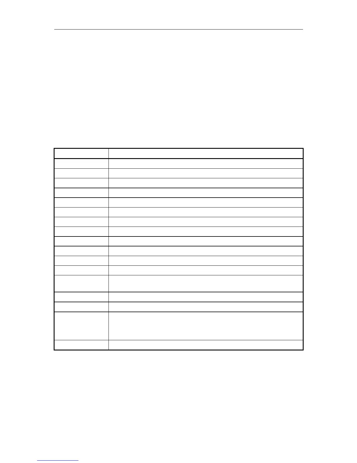
Table 8 describes the DPGGA message fields.
Field Description
hhmmss.ss UTC of position (hours, minutes, seconds).
ddmm.mmmm Latitude (degrees, minutes and fractions of minutes).
a Latitude sector, N - North or S - South.
dddmm.mmmm Longitude (degrees, minutes and fractions of minutes).
a Longitude sector, E - East or W - West.
q DGPS Quality Indicator (DQI): 0-9
nn Number of satellites used in solution.
hh.h HDOP - horizontal dilution of precision 00.0 to 99.9.
u Sign of altitude above or below mean-sea-level.
xxx.x Antenna altitude above mean-sea-level (geoid).
M Unit of altitude, M = meters.
u Sign of geoidal seperation.
xxx.x Geoidal separation, the difference between the WGS-84 ellipsoid and mean-
sea-level (geoid). Negative sign if mean-sea-level is below ellipsoid.
M Unit of Geoidal separation, M = meters.
xx.x Average age of corrections, in seconds. 0 when DGPS not used.
xxxx DGPS system identifier (Text)
e.g. DGPR = DGPS Radio-based link
DGPI = DGPS Inmarsat-based link
*cc Checksum.
Table 8 DPGGA message fields