Seatex DPS 200 Installation Manual, rev. 4 Installation
29
GGA_CEG Message
The GGA_CEG message contains time, position and GPS data. The message is as specified in
NMEA 0183 version 2.2, but the maximum age of differential corrections is 9.9 seconds. The
message structure is as follows:
$GPGGA,hhmmss.ss,ddmm.mmmmmm,s,dddmm.mmmmmm,s,q,nn,h.h,a.a,M,g.g,M,a.a,rrrr
*cc
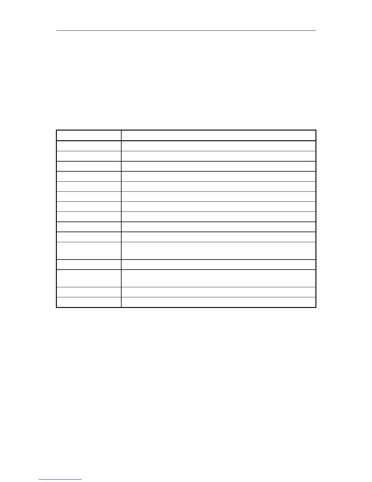
Table 12 describes the GGA_CEG message fields.
Field Description
hhmmss.ss UTC of position (hours, minutes, seconds).
ddmm.mmmmmm Latitude (degrees, minutes and fractions of minutes).
s Latitude sector, N - North or S - South.
dddmm.mmmmmm Longitude (degrees, minutes and fractions of minutes).
s Longitude sector, E - East or W - West.
q GPS Quality indicator: 0 = Fix not valid, 1 = GPS fix, 2 = DGPS fix.
nn Number of satellites in use, 00 - 12.
h.h HDOP - horizontal dilution of precision 00.0 to 99.9.
a.a Altitude, reference: mean-sea-level (geoid).
M Altitude unit, M = meters.
g.g Geoidal separation: the difference between the WGS-84 ellipsoid and
mean-sea-level (geoid).
M Geoidal separation unit, M = meters.
a.a Age of differential corrections, in seconds. 0 when DGPS not used.
Maximum age is 9.9 seconds.
rrrr Differential reference station ID, 0000-1023.
*cc Checksum.
Table 12 GGA_CEG message fields
GLL Message
The GLL message presents latitude and longitude of vessel position, time at position fix and
status. The message is as specified in NMEA 0183 version 2.3 and 3.0. The message structure
is as follows:
$GPGLL,ddmm.mmmmmm,s,dddmm.mmmmmm,s,hhmmss.ss,A,a*cc
Table 13 describes the GLL message fields.