Do you have a question about the Leica TS07 and is the answer not in the manual?
Explains how safety directions and warning messages help anticipate and avoid hazards.
Details risks like electrocution, lightning strikes, distraction, and improper accessory securing.
Covers laser classification, general safety, and specific laser product details.
Explains product capability in environments with electromagnetic radiation and static discharge.
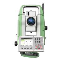
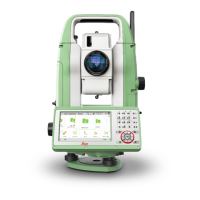
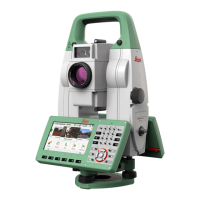
Describes the instrument's keyboard layout, function keys, and specific key functions.
Guides through the process of setting up the instrument, including tripod use and leveling.
Provides guidelines for correct distance measurements, covering prism and non-prism modes.
Configures EDM mode, target types, measurement modes, prism constants, laser pointer, and guide light.
Provides tools for electronic adjustment of instrument errors like collimation, index, and tilting axis.
Details how to activate PIN protection for unauthorized use and lock the instrument.
Explains how to determine station coordinates and orientation for accurate measurements.
Details the process and methods for setting up a station, including coordinate and orientation determination.
Explains various methods for station setup like Resection, Helmert, and Orientation.
Covers entering station data, measuring target points, and determining instrument height.
Used for measuring an unlimited number of points, including pre-settings for job, station, and orientation.
Explains different modes for staking out points: Polar, Orthogonal, and Cartesian.
Configures prefix/suffix, identifier, beep alerts, point filtering, radius, and point ID range for staking.
Introduces the Reference Line app for staking or checking lines, including line & offset, stakeout, and segmentation.
Explains how to define a base line using two base points, measured or entered manually.
Details how to define a reference line by offsetting or rotating a base line.
Calculates differences between measured and calculated points for staking out relative to a reference line.
Explains stakeout procedures for points and arcs relative to a reference line.
Calculates stakeout elements for points on a grid defined relative to a reference line.
Divides a reference line into segments for stakeout, calculating elements based on segment number or length.
Introduces the Reference Arc app for defining and working with arcs.
Details methods for defining a reference arc using center/start points, start/end/radius, or three points.
Explains how to define a reference arc using different input methods and shows potential mathematical solutions.
Supports staking out points, arcs, chords, and angles relative to a reference arc.
Details methods for staking out points, arcs, chords, and angles relative to a reference arc.
Used to measure points relative to a reference plane and calculate offsets and intersection points.
Introduces app for computing areas and volumes, including 2D/3D area, area to reference plane, and DTM volume.
Guides on calculating volumes using breakline points and defining areas for DTM volume computation.
Used to compute points directly above a base prism without needing a prism at the target point.
Performs coordinate geometry calculations like inverse, traverse, intersections, offsets, and line extensions.
Measures or stakes out points relative to defined road elements like lines, curves, or spirals with chainage and offsets.
Used for staking or as-built checks relative to road alignments, including slopes and vertical alignments.
Used to stake out points relative to an existing alignment, considering height differences and defined chainage.
Performs as-built checks on points, comparing chainage and offset values to existing alignments.
Stakes out catch points based on defined slopes, hinge points, and chainage.
Used to establish control networks, including topographic surveys and point stakeouts.
Guides through starting and configuring a traverse, including station data and method selection.
Explains how to measure traverse points with or without a known backsight or known azimuth.
Details methods for closing a traverse at a known station, to a known point, or leaving it open.
Details procedures for correcting line-of-sight (horizontal collimation) and vertical index errors.
Explains how to adjust longitudinal and transversal compensator index errors electronically.
Describes the procedure to determine and correct the tilting axis error affecting horizontal angles.
Details the steps to activate theft protection, including setting renewal dates and connecting to myWorld.
Describes how to check status, report an instrument as stolen, and the process for locating a stolen device.
Lists ranges and atmospheric conditions for distance measurements using various reflectors and modes.
Provides ranges, accuracies, and atmospheric conditions for distance measurements without using reflectors.
| Distance Measurement Accuracy (Non-Prism / Reflectorless) | 2 mm + 2 ppm |
|---|---|
| Operating Temperature | -20°C to +50°C |
| Protection Class | IP55 |
| Laser Plummet Accuracy | 1.5 mm at 1.5 m |
| Distance Measurement Accuracy (Prism) | 1.5 mm + 2 ppm |
| Distance Range (Prism) | Up to 3, 500 m |
| Distance Range (Non-Prism / Reflectorless) | Up to 1, 000 m |
| Display | Graphical color touchscreen |
| Data Storage | SD card |
| Communication | USB, Bluetooth |
| Weight | 5.3 kg |
| Angle Measurement Accuracy | 1", 2", 3", 5" |