Do you have a question about the Leica TS01 and is the answer not in the manual?
Details on model/serial numbers and manual applicability.
Introduction to myWorld services like myProducts and myService.
Directions to anticipate and avoid operational hazards.
Explanation of signal words: DANGER, WARNING, CAUTION, NOTICE.
Defines proper usage and reasonably foreseeable misuse.
Suitable environments and limits for operation.
Defines responsibilities of Leica Geosystems and product users.
Covers dropping, electrocution, lightning, distraction, site security.
Instructions on laser safety standards IEC 60825-1.
Laser class 1 specifications and safety.
Laser class 3R specifications and potential hazards.
Laser pointer specifications and safety precautions.
Laser plummet specifications and safety.
How radiation can disturb other equipment or vice versa.
Precautions when using third-party accessories or phones.
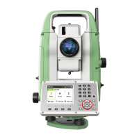
Identifies TS01, software, and data transfer.
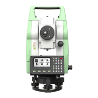
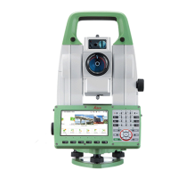
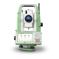
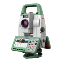
Detailed breakdown of physical instrument parts.
Explanation of all keys on the instrument's keyboard.
Understanding the screen display, fields, and status icons.
Functionality of common softkeys used in the system.
Turning on/off, using the keypad, and editing fields.
How to search for recorded points or fixpoints.
Detailed steps for instrument setup and tripod handling.
Step-by-step guide for precise instrument leveling.
Guidelines for first-time use, charging, and operation.
Step-by-step instructions for changing the instrument battery.
How data is stored internally and transferred via USB.
Navigating the Main Menu and measurement screens.
Measuring horizontal and vertical angles, setting angles.
Steps for measuring distances and viewing results.
Steps for measuring and recording coordinates.
Tips for accurate measurements without reflectors.
Tips for accurate measurements using prisms.
Setting units for angles, temperature, pressure, and distance.
Configuring compensator and horizontal correction settings.
Setting measurement modes and display formats.
Adjusting contrast, beep, and assigning shortcut keys.
Configuring Electronic Distance Measurement parameters.
Setting up Wi-Fi connectivity and hotspot.
Lists common surveying applications like Survey, Set Out, etc.
Procedure for selecting, starting, and pre-setting apps.
Defining the instrument station coordinates.
Methods for setting the instrument's orientation.
Creating, selecting, and managing jobs for data.
Description of frequently used data fields across apps.
Measuring an unlimited number of points with pre-settings.
Placing marks in the field at predetermined points.
Calculates target coordinates using various offset methods.
Computes distances and azimuths between two points.
Computes points directly above a base prism.
Computes online areas up to 50 points connected by straights.
Determines instrument position using measurements to known points.
Stake out or measure points relative to a defined line.
Tools for stake out and checks relative to road alignments.
Definitions for road alignment elements like straight, curve, spiral.
Steps to define horizontal and vertical road alignments.
Staking out points relative to an existing alignment.
Exporting and importing road data via USB memory stick.
Assigning codes to recorded points for later processing.
Functions for entering, editing, checking, and deleting data.
Viewing memory status and erasing data.
Guidelines and precautions for using USB memory sticks.
Procedures for exporting job data in various formats.
Procedures for importing data from USB memory sticks.
Procedures for checking and adjusting instrument accuracy.
Correcting line-of-sight and vertical index errors.
Steps for adjusting the instrument's compensator.
How to adjust the levels of the instrument and tribrach.
Procedures for inspecting the laser plummet.
Tips for servicing and tightening tripod components.
Accessing system info and loading firmware or licenses.
Methods for safely transporting the instrument in various conditions.
Recommendations for storing the equipment and batteries.
Instructions for cleaning lenses, prisms, and accessories.
Specifications for angular accuracy and display resolution.
Range, accuracy, and characteristics for reflector measurements.
Specifications for non-prism mode measurements.
Telescope, compensation, level, control unit, ports, dimensions.
Details on battery, operating temp, protection, and humidity.
EU and FCC declarations of conformity, FCC exposure statement.
Safety guidelines for lithium batteries during transport.
Methods for correcting measurements based on atmospheric conditions.
Mathematical formulas for distance and height calculations.
Details on software terms, warranty, and intellectual property.
Hierarchical listing of all instrument menu options.
Organization of files and directories on internal memory.
| Brand | Leica |
|---|---|
| Model | TS01 |
| Category | Measuring Instruments |
| Language | English |